Our blog tracks Jose Arguelles' Dreamspell Calendar. "As chaos and confusion rise, galactic consciousness based on the Law of Time serves as planetary medicine, lifting us into the awareness that we exist within a higher, more expanded realm of existence than the world of third-dimensional form and appearance. Daily practice will elevate consciousness and increase experiences of synchronicity." (Arguelles)
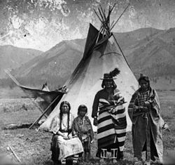
Snake Indians is a collective name given to the Northern Paiute, Bannock, and Shoshone Native American tribes.
The term was used as early as 1739 by French trader and explorer Pierre Gaultier de Varennes, Sieur de la Verendrye when he described hearing of the Gens du Serpent ("Snake people") from the Mandans. This is probably the first written mention of the Shoshone people. The term "Snakes" is also used to refer the Shoshone by British explorers David Thompson and Anthony Henday.
This term was widely used by American immigrants on the Oregon Trail in the Snake River and Owyhee River valleys of southern Idaho and Eastern Oregon. The term "Snake Indian" later included the Northern Paiute tribes found in the basins between the Cascade Mountains and these valleys in Oregon and northern Nevada and northeastern California. These people were the opponents of the California and Oregon Volunteers and U.S Army, in the Snake War.
From the 1688-1720s, when the British Empire first came into prolonged trade contact with the Western Cree and Blackfoot, both of these groups were united in war against "the Snake Indians" of Canada. It is not clear if this term (used in this period of Canadian history) is meant to refer to Northern Paiute people, or if it is inaccurate, or perhaps entirely unrelated.*
The Klickitat (also spelled Klikitat) are a Native American tribe of the Pacific Northwest. Today they are enrolled in the federally recognized Confederated Tribes and Bands of the Yakama Nation.
A Shahaptian tribe, their eastern neighbors were the Yakama, who speak a closely related language. Their western neighbors were various Salishan and Chinookan tribes. Their name has been perpetuated in Klickitat County, Washington, Klickitat, Washington, Klickitat Street in Portland, Oregon, and the Klickitat River, a tributary of the Columbia River.
The Klickitat were noted for being active and enterprising traders, and served as intermediaries between the coastal tribes and those living east of the Cascade Mountains.
The ancestral lands of the Klickitat were situated north of the Columbia River, at the headwaters of the Cowlitz, Lewis, White Salmon, and Klickitat rivers, in present-day Klickitat and Skamania Counties. They occupied their later base after the Yakama crossed this river. In 1805, the Klickitat were encountered by the Lewis and Clark Expedition. Lewis and Clark found them wintering on the Yakima and Klickitat Rivers and estimated their number at about 700.
In the early 1850s, the Klickitat Tribe raided present-day Jackson County, Oregon from the north and settled the area. Modoc, Shasta, Takelma, Latgawas, and Umpqua Indian tribes had already lived within the present boundaries of that county.
Between 1820 and 1830, an epidemic of fever struck the tribes of the Willamette Valley. The Klickitat took advantage of the drop in population in this region and crossed the Columbia River and occupied territory occupied by the Umpqua. This was not permanent, however, as they were pushed back to their original homeland.
The Klickitat War erupted in 1855. The Klickitat capitulated and joined in the Yakima treaty at Camp Stevens on June 9, 1855. They ceded their lands to the United States. Most of them settled upon the Yakima Indian Reservation.
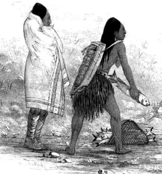
The Klickitats were noted to trade Salmon, Roots, and Berries and to have two chiefs within the tribe that welcomed Lewis and Clark on their arrival.*
The Confederated Salish and Kootenai Tribes of the Flathead Reservation are the Bitterroot Salish, Kootenai and Pend d'Oreilles (Upper Kalispel) (pronounced: “pond-oray”) tribes. They were incorrectly called the Flathead Indians by the first Europeans who came to the area. The Flatheads call themselves Salish, meaning “the people”. These people never practiced head flattening, but their Columbia River neighbors shaped their own heads to create a pointed appearance, and called the Salish "flatheads" in contrast.
The Flatheads lived between the Cascade Mountains and Rocky Mountains. The Salish (Flatheads) initially lived entirely east of the Continental Divide but established their headquarters near the eastern slope of the Rocky Mountains. Occasionally, hunting parties went west of the Continental Divide but not west of the Bitterroot Range. The easternmost edge of their ancestral hunting forays were the Gallatin, Crazy Mountain, and Little Belt Ranges.
The first written record of the tribes is from their meeting with the Lewis and Clark Expedition (September 4, 1805). Lewis and Clark came there and asked for horses but eventually ate the horses due to starvation. The Flatheads also appear in the records of the Roman Catholic Church at St. Louis, Missouri, to which they sent four delegations to request missionaries (or "Black Robes") to minister to the tribe. Their request was finally granted, and a number of missionaries, including Pierre-Jean De Smet, S.J., were eventually sent. The Flatheads are also located in Sula, Montana.
The tribes negotiated the Hellgate treaty with the United States in 1855. From the start, treaty negotiations were plagued by serious translation problems. A Jesuit observer, Father Adrian Hoecken, said that the translations were so poor that "not a tenth of what was said was understood by either side." But as in the meeting with Lewis and Clark, the pervasive cross-cultural miscommunication ran even deeper than problems of language and translation. Tribal people came to the meeting assuming they were going to formalize an already-recognized friendship. Non-Indians came with the goal of making official their claims to native lands and resources. Isaac Stevens, the new governor and superintendent of Indian affairs for the Washington Territory, was intent on obtaining cession of the Bitterroot Valley from the Salish. Many non-Indians were already well aware of the valley's potential value for agriculture and its relatively temperate climate in winter. Because of the resistance of Chief Victor (Many Horses), Stevens ended up inserting into the treaty complicated (and doubtless poorly translated) language that defined the Bitterroot Valley south of Lolo Creek as a "conditional reservation" for the Salish. Victor put his X mark on the document, convinced that the agreement would not require his people to leave their homeland. No other word came from the government for the next fifteen years, so the Salish assumed that they would indeed stay in their Bitterroot Valley forever.
After the 1864 gold rush in the newly established Montana Territory, pressure upon the Salish intensified from both illegal non-Indian squatters and government officials. In 1870, Victor died, and he was succeeded as chief by his son, Chief Charlot (aka Charlo, Claw of the Little Grizzly). Like his father, Charlot adhered to a policy of nonviolent resistance. He insisted on the right of his people to remain in the Bitterroot Valley. But territorial citizens and officials thought the new chief could be pressured into capitulating. In 1871, they successfully lobbied President Ulysses S. Grant to declare that the survey required by the treaty had been conducted and that it had found that the Jocko (Flathead) Reservation was better suited to the needs of the Salish. On the basis of Grant's executive order, Congress sent a delegation, led by future president James Garfield, to make arrangements with the tribe for their removal. Charlot ignored their demands and even their threats of bloodshed, and he again refused to sign any agreement to leave. U.S. officials then simply forged Charlot's "X" onto the official copy of the agreement that was sent to the Senate for ratification.
Over time, the real reason for the Hellgate treaty meetings became clear to the Salish and Pend d'Oreille people. Under the terms spelled out in the written document, the tribes ceded to the United States more than twenty million acres (81,000 km²) of land and reserved from cession about 1.3 million acres (5300 km²), thus forming the Jocko or Flathead Indian Reservation. Conditions had become intolerable for the Salish by the late 1880s, after the Missoula and Bitter Root Valley Railroad was constructed directly through the tribe's lands, with neither permission from the native owners nor payment to them. Charlot finally signed an agreement to leave the Bitterroot Valley in November 1889. Inaction by Congress, however, delayed the removal for another two years, and according to some observers, the tribe's desperation reached a level of outright starvation. In October 1891, a contingent of troops from Fort Missoula forced Charlot and the Salish out of the Bitterroot and roughly marched the small band sixty miles to the Flathead Reservation.
The three main tribes moved to the Flathead Reservation were the Bitteroot Salish, the Pend d'Oreille, and the Kootenai. The Bitterroot Salish and the Pend d'Oreille tribes spoke dialects of the same Salish language.
A dispute over off-reservation hunting between a band of Pend d'Oreilles and the state of Montana's Fish and Game department resulted in the Swan Valley Massacre of 1908.
Though marked for termination in 1953 under the House concurrent resolution 108 of the US federal Indian termination policy, the Flathead Tribes were able to resist the government's plans to terminate their tribal relationship in Congressional hearings in 1954.
The tribe has about 6,800 members with approximately 4,000 tribal members living on the Flathead Reservation as of 2013, and 2,800 tribal members living off the reservation. Their predominant religion is Roman Catholicism. 1,100 Native Americans from other tribes and more than 10,000 non-Native Americans also live on the reservation.
As the first to organize a tribal government under the Indian Reorganization Act of 1934, the tribes are governed by a tribal council. The Tribal Council has ten members, and the council elects from within a Chairman, Vice Chairman, Secretary and Treasurer. The tribal government offers a number of services to tribal members and is the chief employer on the reservation. The tribes operate a tribal college, the Salish Kootenai College, and a heritage museum called “The People’s Center” in Pablo, seat of the tribal government.*
Cowlitz people are a southwestern Coast Salish indigenous peoples of the Pacific Northwest. Today they are enrolled in the federally recognized tribes: Cowlitz Indian Tribe, Quinault Indian Nation and the Confederated Tribes of the Chehalis Reservation.
Their traditional homelands are in western Washington state in the United States. The Cowlitz tribe consists of two distinct groups: the Upper Cowlitz, or Taidnapam, and the Lower Cowlitz, or Kwalhiokwa.
The original language of Cowlitz tribes, the Cowlitz language, belonged to the Salishan family of languages among Northwest Coast indigenous peoples. Later, the Upper Cowlitz adopted the Sahaptin language from east of the Cascade Mountains. Modeste Demers reported that the Cowlitz peoples were fluent in Chinook Jargon.
The Cowlitz Indian Tribe were federally recognized on February 14, 2000, and their acknowledgement was reaffirmed in 2002. They are now recognized officially by the United States federal government, and are in the process of establishing federally recognized tribal lands (such as on a reservation) near Longview, Washington. The tribal offices are in Longview, Washington.
The Cowlitz political system evolved:
"from a strong system of chiefs, to an elective presidential system in the early 20th century; and a constitutional elective Tribal Council system after 1950. Chief How-How (c. 1815), Chief Kiscox (c. 1850), Chief Umtux (c. 1850), Chief Scanewa (c. 1855), Chief Richard Scanewa (c. 1860) and Chief Antoine Stockum [Atwin Stokum] (1878) led the Cowlitz in the 19th century. Twentieth century figures include Chief Baptiste Kiona (1912), President Dan Plamondon (1921), President John Ike Kinswa (1922), Chairman John B. Sareault (c. 1925), Chairman Jas. E. Sareault (c. 1930), Chairman Manual L. Forrest (1950), Chairman Joseph Cloquet (1959), Chairman Clifford Wilson (1961) and Chairman Roy Wilson (1974).
The Cowlitz produced fully imbricated, coiled baskets with strong geometric designs. These were made of bear grass, cedar root, horse tail root and cedar bark and were used to gather berries and fruits. Such baskets were often repaired and kept through many generations.
The Cowlitz tribe was historically based along the Cowlitz and Lewis Rivers, as well as having a strong presence at Fort Vancouver. The first white known to have contacted the Cowlitz was French-Canadian Simon Plamondon of Quebec. He eventually married Chief Scanewea's daughter, Thas-e-muth. Several other French-Canadians settled near by Plamondon and also took up farming. Catholic missionaries began to visit the Cowlitz people in late 1838, with the St. Francis Xavier Mission eventually being built there. In December of that year, François N. Blanchet preached from Plamondon's residence to the farmers and several Cowlitz natives. After the priest left, the Cowlitzes reportly told the French-Canadian farmers that "We want to do something for them, we will work, make fences, and whatever they wish us to do." The Hudson's Bay Company agricultural subsidiary Puget Sound Agricultural Company established Fort Cowlitz in 1839.*
Colville Business Council and some hereditary chiefs and elders in 1941.
The Colville Indian Reservation is a Native American reservation in the north-central part of the U.S. state of Washington, inhabited and managed by the Confederated Tribes of the Colville Reservation, which is federally recognized. Established in 1872, the reservation currently consists of 2,825,000 acres (1,143,000 ha). It is located primarily in the southeastern section of Okanogan County and the southern half of Ferry County, but it includes other pieces of trust land in eastern Washington, including in Chelan County, just to the northwest of the city of Chelan. The reservation's name is adapted from that of Fort Colville, which was named by British colonists for Andrew Colville, a London governor of the Hudson's Bay Company.
The Confederated Tribes have 8,700 descendants from 12 aboriginal tribes. The tribes are known in English as: the Colville, Nespelem, Sanpoil, Lakes (after the Arrow Lakes of British Columbia, or Sinixt), Palus, Wenatchee, Chelan, Entiat, Methow, southern Okanagan, Sinkiuse-Columbia, and Nez Perce of Chief Joseph's Band. Some members of the Spokane tribe also settled the Colville reservation after it was established.
The most common of the indigenous languages spoken on the reservation is Colville-Okanagan, a Salishan language. Other tribes speak other Salishan languages, with the exception of the Nez Perce and Palus, who speak Sahaptian languages.
Before the influx of British and Americans in the mid-1850s, the ancestors of the 12 aboriginal tribes followed seasonal cycles to gather their food sources. They moved to the rivers for salmon and other fish runs, mountain meadows for berries and deer, or the plateau for roots. Their traditional territories were grouped primarily around waterways, such as the Columbia, San Poil, Nespelem, Okanogan, Snake, and Wallowa rivers.
Many tribal ancestors ranged throughout their aboriginal territories and other areas in the Northwest (including British Columbia, Canada), gathering with other native peoples for traditional activities such as food harvesting, feasting, trading, and celebrations that included sports and gambling. Their lives were tied to the cycles of nature, both spiritually and traditionally.[2]
In the mid-19th century, when European-American settlers began competing for trade with the indigenous native peoples, many tribes began to migrate westward. Trading and its goods became a bigger part of their lives.
For a while, Great Britain and the United States disputed the territory of what the latter called the Oregon Country and the former the Columbia District. Both claimed the territory until they agreed on the Oregon Treaty of 1846, which established United States title south of the 49th Parallel. They did not consider any of the indigenous peoples living in those territories to be citizens or entitled to the lands by their own national claims. However, according to the religions and traditions of the indigenous peoples, this territory had been their home land since the time of creation. A succession of indigenous cultures had occupied this region for more than 10,000 years
President Fillmore signed a bill creating the Washington Territory, and he appointed as Commissioner of Indian Affairs, Major Isaac Stevens of the United States Army Corps of Engineers, to meet with the Indians during his exploration for railroad routes. Stevens wrote a report recommending the creation of "reservations" for the people in the Washington Territory. The report said, "contrary to natural rights and usage," the United States should grant lands that would become reservations to the Indians without purchasing from them.
In 1854 negotiations were conducted, "particularly in the vicinity of white settlements, toward extinguishing of the Indian claims to the lands and the concentration of the tribes and fragments of tribes on a few reservations naturally suited to the requirement of the Indians, and located, so far as practicable, so as not to interfere with the settlement of the country."[citation needed]
During this time, continued American settlement created conflicts and competition for resources with the native tribes. It resulted in the Yakima War, which was fought from 1856 to 1859. Negotiations were unsuccessful until 1865. Superintendent McKenny then commented:
"From this report, the necessity of trading with these Indians can scarcely fail to be obvious. They now occupy the best agricultural lands in the whole country and they claim an undisputed right to these lands. White squatters are constantly making claims in their territory and not infrequently invading the actual improvements of the Indians. The state of things cannot but prove disastrous to the peace of the country unless forestalled by a treaty fixing the rights of the Indians and limiting the aggression of the white man. The fact that a portion of the Indians refused all gratuitous presents shows a determination to hold possession of the country here until the government makes satisfactory overtures to open the way of actual purchase."
Seeking to improve relations with the Native Americans, President Grant issued an Executive Order on April 9, 1872, to create an "Indian Reservation" consisting of several million acres of land, containing rivers, streams, timbered forests, grass lands, minerals, plants and animals. People from 11 tribes (the Colville, the Nespelem, the San Poil, Lakes (Sinixt), Palus, Wenatchi, Chelan, Entiat, Methow, southern Okanogan, and the Moses Columbia) were "designated" to live on a new Colville Indian Reservation.
That original reservation was west of the Columbia River. Less than three months later, the President issued another executive order on July 2, 1872 moving the reservation further west, to reach from the Columbia River on the west and south, to the Okanogan River on the east, and the Canada–US border to the north. The new reservation was smaller, at 2,852,000 acres (11,540 km2). The Tribes' historic native lands of the Okanogan River, Methow Valley, and other large areas along the Columbia and Pend d'Orielle rivers, along with the Colville Valley, were excluded. The areas removed from the reservation were some of the richest in terms of fertility of land and available natural resources.
Twenty years later, the United States changed government policy, intending to dissolve Indian reservations throughout the United States and make allotments of land to individual households in order to encourage subsistence farming. (This would also "free" land declared excess to tribal needs to be sold to non-Native Americans.) Under the General Allotment Act (Dawes Act) of 1887, the members of the tribes at the Colville reservation were registered and land allotted. An 1892 act of Congress removed the north half of the reservation (now known as the Old North Half) from tribal control, with allotments made to Indians then living on it, and the rest opened up for settlement by others. In 1891, the tribes had entered into an agreement with the federal government to vacate the Old North Half, in exchange for $1.5 million ($1 per acre) and continued hunting and fishing rights, but the 1892 act was based only loosely on that agreement. The government did not complete payments for the land for 14 years. But the tribes retained their hunting and fishing rights to their former reservation land (superior to those of non-members). As was customary then in reservation allotments, individual Indians living on the Old North Half who refused to move to the remaining south half were allotted only 80 acres (32 ha) of land, rather than the 160 acres they would have received within the southern reservation boundaries.
The remainder of the communal reservation land was allotted to households, in the same 80-acre amounts, and tribal authority ended, by act of Congress in 1906. The government declared the land not allotted to be excess to tribal needs and opened it for settlement in 1916 by Presidential proclamation. The allotment act was based on an agreement negotiated between the tribes and Indian agent James McLaughlin, signed by 2/3 of the adult male Indians then living on the reservation (of whom there were approximately 600). The Dawes Act enacted a US policy of terminating reservations and tribal government, and did not require any consent by or compensation to Indians. Agreements that Indians did sign were not entirely mutual. They were concerned more with the details of the allotment than the fact of it.
In the face of loss of lands and considerable social distress, President Franklin D. Roosevelt changed federal policy toward the tribes. The Indian Reorganization Act of 1934 reversed the policy of dissolution of reservations and immediately halted the transfer of reservation land to private ownership. Tribes were encouraged to re-establish their tribal governments and establish constitutions based on democratic electoral models.
In 1956, Congress restored tribal control to the Colville Tribes over all land in the south half that was not yet privately owned. In the time since then, the tribe has gradually purchased private land on the reservation and had it placed back into trust status as tribal land. Since the late 20th century, they have received some of the funds for this from the federal government, pursuant to lawsuits, as compensation for the government's mismanagement of the trust lands and insufficient compensation to Indians for former reservation land. In addition, President Barack Obama established a Buy-Back Program.*
Indigenous peoples of the Northwest Plateau, also referred to by the phrase Indigenous peoples of the Plateau, and historically called the Plateau Indians (though comprising many groups) are indigenous peoples of the Interior of British Columbia, Canada, and the non-coastal regions of the United States Pacific Northwest states.
Their territories are located in the inland portions of the basins of the Columbia and Fraser Rivers. These tribes live in parts of the Central and Southern Interior of British Columbia, northern Idaho, western Montana, eastern Washington, eastern Oregon, and northeastern California. The eastern flank of the Cascade Range lies within the territory of the Plateau peoples.
In Canada, the greater part of the Interior Plateau was inhabited by Interior Salish peoples: the Lillooet tribe whose homelands are in the Lillooet River Valley; the Thompson First Nations, whose homelands are in the Fraser River Valley from Yale to Lillooet; the Secwepemc (Shuswap) of the Fraser River Valley from Lillooet to Alexandria, the upper parts of the Thompson River basin, and areas further east; the Okanagan of the Okanagan River Valley and its vicinity; also the Lakes people of the Arrow Lakes. The Kutenai tribe, who live in the southeastern parts of British Columbia and formerly extended to southwestern Alberta, speak an isolate language. Athapaskan-speaking people, the Chilcotin and Carrier, occupy the northernmost part of the Plateau region.
The First Nations of the Plateau were influenced by the First Nations of the Pacific Coast. The Plateau First Nations traded many goods with the Pacific Coast First Nations. The Pacific tribes believed in clan ancestors which were adopted by the Interior Salish groups, but they did not adopt the social system.*
The closer we get to the present moment, the more details there are - this is because the closer we get to the present, the more we have to remember and the more material archives we need in order to hold all of the information bits.*
*Star Traveler's 13 Moon Almanac of Synchronicity, Galactic Research Institute, Law of Time Press, Ashland, Oregon, 2016-2017.
Chinook people meet the Corps of Discovery on the Lower Columbia, October 1805
(Charles Marion Russel, c. 1905).
Chinookan peoples include several groups of indigenous people of the Pacific Northwest in the United States speaking the Chinookan languages. In the early 19th century, the Chinookan-speaking peoples resided along the lower and middle Columbia River in present-day Oregon and Washington. The Chinook tribes were those encountered by the Lewis and Clark Expedition in 1805 on the lower Columbia.
Since the late 20th century, the Chinook Indian Nation, made up of 2700 members of several peoples, has worked to obtain federal recognition. It gained this in 2001 but, was later revoked in 2002 because it did not meet the proper criteria of the B.I.A.. The tribe continues to seek recognition.
The Chinookan peoples were not nomadic but rather occupied traditional tribal geographic areas. They had a society marked by social stratification consisting of a number of distinct social castes of greater or lesser status. Upper castes included shamans, warriors, and successful traders, and were a minority of the community population compared to common members of the tribal group. Members of the superior castes are said to have practiced social isolation, limiting contact with commoners and forbidding play between the children of the different social groups.
Some Chinookan peoples practiced slavery, a practice borrowed from the northernmost tribes of the Pacific Northwest. They encouraged their slaves, taken as captives in warfare, to practice thievery on behalf of their masters. The latter refrained from such practices as unworthy of high status.
At birth some Chinookan tribes would flatten children's heads by binding them under pressure between boards, a process said to have been initiated when the infant was about 3 months old and to have continued until the child was about one year of age. This served as a means of marking social hierarchy; flat-headed community members were ranked above those with round heads. Those with flattened and deformed skulls refused to enslave other individuals who were similarly marked, thereby reinforcing the association of a round head with servility. The Chinook were known colloquially by early white explorers in the region as "Flathead Indians."
Living near the coast of the Pacific Ocean, they were skilled elk hunters and fishermen. The most popular fish was salmon. Owing partly to their settled living patterns, the Chinook and other coastal tribes had relatively little conflict over land as they did not migrate through each other's territories. In the manner of numerous settled tribes, they resided in long houses. More than fifty people, related through extended kinship, often resided in one long house.
The Chinook Indian Nation has engaged in a continuing effort since the late 20th century to secure formal recognition as a sovereign tribe by the U.S. federal government. In 2001, the U.S. Department of Interior recognized the Chinook Indian Nation, a confederation of the Cathlamet, Clatsop, Lower Chinook, Whkaikum and Willapa Indians, as a tribe during the last months of the administration of President Bill Clinton. After the administration changed under President George W. Bush, his new political appointees reviewed the materials and, in 2002, revoked this status, in what was a highly unusual action. Efforts by Brian Baird, D-Wash. from Washington's 3rd congressional district, to gain passage of legislation to achieve recognition in 2011 were not successful.*
Elizabeth Woody at the petroglyph Tsagaglallal, or She-Who-Watches. Elizabeth. Woody (Navaho/Warm Springs/Wasco/Yakama) received the American Book Award for her collection of poetry "Hand into Stone." She is the Director of the Indigenous Leadership program for Ecotrust.
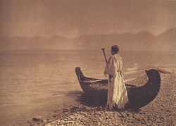
Along the mid-Columbia River ninety miles east of Portland, Oregon, stand Celilo Indian Village and Celilo Park. Beside the eastbound lanes of Interstate 84 are a peaked-roof longhouse and a large metal building. The houses in the village are older, and easy to overlook. You can sometimes see nets and boats beside the homes, though some houses are empty. By comparison, the park is frequently filled with lively and colorful wind surfers. Submerged beneath the shimmering surface of the river lies Celilo Falls, or Wyam.
Wyam means "Echo of Falling Water" or "Sound of Water upon the Rocks." Located on the fourth-largest North American waterway, it was one of the most significant fisheries of the Columbia River system. In recent decades the greatest irreversible change occurred in the middle Columbia as the Celilo site was inundated by The Dalles Dam on March 10, 1957. The tribal people who gathered there did not believe it possible.
Historically, the Wyampum lived at Wyam for over twelve thousand years. Estimates vary, but Wyam is among the longest continuously inhabited communities in North America. The elders tell us we have been here from time immemorial.
When the fish ran, people were wealthy. People from all over the country would come to Celilo to watch the "Indians" catch fish. They would purchase fish freshly caught. It was one of the most famous tourist sites in North America. And many long-time Oregonians and Washingtonians today differentiate themselves from newcomers by their fond memories of Celilo Falls.
What happened at Wyam was more significant than entertainment. During the day, women cleaned large amounts of finely cut fish and hung the parts to dry in the heat of the arid landscape. So abundant were the fish passing Wyam on their upriver journey that the fish caught there could feed a whole family through the winter. Many families had enough salmon to trade with other tribes or individuals for specialty items.
The songs in the "ceremonial response to the Creator" are repeated seven times by seven drummers, a bell ringer, and people gathered in the Longhouse. Washat song is an ancient method of worship. By wearing the finest Indian dress, the dancers show respect to the Creator.
Men on the south side, women on the north, the dancers begin to move. In a pattern of a complete circle they dance sideways, counterclockwise. This ceremony symbolizes the partnership of men and women, the essential equality and balance within the four directions and the cosmos. We each have our place and our role. As a result, the Longhouse is a special place to learn.* by Elizabeth Woody *http://www.salmonnation.com/index.php
MANIK
Kin 247: Blue Cosmic Hand
I endure in order to know
Transcending healing
I seal the store of accomplishment
With the cosmic tone of presence
I am guided by the power of magic.
The purified planetary human operates with a noospheric compassionate consciousness turned in to the whole life of the planet.*
*Star Traveler's 13 Moon Almanac of Synchronicity, Galactic Research Institute, Law of Time Press, Ashland, Oregon, 2015-2016.