Our blog tracks Jose Arguelles' Dreamspell Calendar. "As chaos and confusion rise, galactic consciousness based on the Law of Time serves as planetary medicine, lifting us into the awareness that we exist within a higher, more expanded realm of existence than the world of third-dimensional form and appearance. Daily practice will elevate consciousness and increase experiences of synchronicity." (Arguelles)
The Neusiok people lived "on the south side of lower Neuse river, within the present Lenoir, Craven and Carteret Counties, North Carolina."
In one account, Wingina, Weroance of the Secotan (Roanoke) Indians, explained his own tribal history, in relation to the Neusiok, his neighboring tribe, referred to as the "Neiosioke" by Barlowe. According to Wingina, the Secotans endured years of warfare with the Neiosioke, and "some years earlier," he met with the Neiosioke king, in an effort to ensure a "permanent coexistence." The two leaders arranged a feast between the two groups. An unspecified number of Secotan men and 30 women attended a feast in the town of Neiosioke. The Neiosioke ambushed the Secotans at the feast, and by the time fighting ended, the Neiosioke had "slewn them every one, reserving the women and children only."*
The Nansemond have been recognized as a Native American tribe by the Commonwealth of Virginia, along with ten other Virginia Indian tribes. They are not federally recognized but are one of six Virginia tribes without reservations that are included in a bill for federal recognition under consideration by the United States Congress.
Most members of the tribe live in the Suffolk/Chesapeake, Virginia area. At the time of European encounter, the historic Nansemond tribe spoke one of the Algonquian languages.
The Nansemond were members of the Powhatan chiefdom. They lived along the Nansemond River, an area they called Chuckatuck. In 1607, when English people arrived to settle at Jamestown, the Nansemond were initially wary.
In 1608, the English raided one of the Nansemond towns, burning houses and destroying canoes to force the people to give corn to the settlers. Captain John Smith and his men demanded 400 bushels of corn or threatened to destroy the village, remaining canoes, and houses. The tribe agreed, and Smith and his men left with most of the tribe's corn supply. They returned the following month for the rest, which left the tribe in bad shape for the winter. Relations between the English and the Nansemond deteriorated further in 1609 when the English tried to gain control of Dumpling Island, where the head chief lived and where the tribe's temples and sacred items were kept. The English destroyed the burial sites of tribal leaders and temples. Houses and religious sites were ransacked for valuables, such as pearls and copper ornaments, that were buried with the bodies of leaders. By the 1630s, the English began to move into Nansemond lands, with mixed reactions.
John Basse, an early settler in Virginia, married Elizabeth, the daughter of the King of the Nansemond Nation in Holy Baptism and in Holy Matrimony August 14, 1638. Basse was born 7 September 1616; died 1699.
They had 8 children (Elizabeth; John; Jordan; Keziah; Nathaniel; Richard; Samuel; William). They are related to the Coppedge/Coppage/Coppidge Family.
Some Nansemond claim descent from this marriage. Based on her research, Dr. Helen C. Rountree says that all current Nansemond descend from this marriage, making the tribe a family affair.
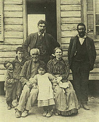
The photo above shows members of the Weaver and Bass families, ca. 1900:
"William H. Weaver is sitting; Augustus Bass is standing behind him. The Weaver family were indentured East Indians (from modern-day India and Pakistan) who were free in Lancaster County by about 1710. By 1732 they were "taxables" [note: free blacks and Indians had to pay a tax in Virginia and North Carolina] in Norfolk County and taxable "Mulatto" landowners in nearby Hertford County, North Carolina by 1741.
The Nansemond were affected by English colonial pressures in the 17th century and split apart. Those who were Christian and had adopted more English customs stayed along the Nansemond River as farmers. "The other Nansemonds warred with the English in 1644, fled southwest to the Nottoway River, and had a reservation assigned them there by the Virginia colony. By 1744 they had ceased using the reservation and gone to live with the Nottoway Indians [note: this was an Iroquoian-language tribe] on another reservation nearby... The Nansemond sold their reservation in 1792 and were known as "citizen" Indians.
Today, the Nansemond have about 200 tribal members. As a "citizen tribe", they gained recognition by Virginia in 1984. The disruption of wars and loss of records in Virginia would make it difficult for them to provide the extensive documentation needed for federal recognition. The current Chief is Barry "Big Buck" Bass. The Nansemond are one of the few state-recognized tribes in Virginia that have not purchased land for their tribe. But, they are trying to get the city of Suffolk to give up 100 acres (0.40 km2) of an 1,100-acre (4.5 km2) riverfront park. They want to use this land to reconstruct Mattanock, a town of their ancestors. They plan to attract tourists by demonstrating their heritage. The tribe has enlisted the help of Helen C. Rountree, whose research helped identify Mattanock Town's location. The village would utilize archaeological and other research to assure the proper dimensions of longhouses to be built on the site..
In August 2013 the City of Suffolk transferred Nansemond ancestral lands back to the tribe. In November 2013 members of the Nansemond Tribe gathered at the site of Mattanock Town and blessed the land.*
The Muscogee (Creek) Nation is a federally recognized tribe of Muscogee people, also known as the Creek, based in the U.S. state of Oklahoma. Calling themselves Este Mvskokvlk, they are regarded as one of the historical Five Civilized Tribes of the American Southeast. The tribe is descended from the historic Creek Confederacy, a large, heterogeneous group of indigenous peoples of the Southeastern Woodlands.
The Muscogee (Creek) Nation is the largest of the federally recognized Muscogee tribes. The Muskogean-speaking Alabama, Hitchiti, and Natchez people, as well as Algonquian-speaking Shawnee and Yuchi are enrolled in the Muscogee Creek Nation. Historically the latter two groups were from different language families than the Muscogee.
Other federally recognized Muscogee groups include the Alabama-Quassarte Tribal Town, Kialegee Tribal Town, and Thlopthlocco Tribal Town of Oklahoma, the Coushatta Tribe of Louisiana, the Alabama-Coushatta Tribe of Texas, and the Poarch Band of Creeks in Alabama.
The Muscogee (Creek) Nation is headquartered in Okmulgee, Oklahoma. Oklahoma Indian tribes do not have reservations (with two exceptions); they have Tribal Jurisdictional Areas. The Muscogee Nation has jurisdiction over tribal members in Creek, Hughes, Okfuskee, Okmulgee, McIntosh, Muskogee, Tulsa, and Wagoner counties in Oklahoma.
In 2013, there were 77,061 people enrolled in the Muscogee Creek Nation. Of these, 55,591 lived within the state of Oklahoma. Since 1979, membership to the tribe is based on documented lineal descent from persons listed as Creek 'Indians by Blood' on the Dawes Rolls. The tribe does not have a minimum blood quantum requirement.
The Nation includes the Creek people and descendants of their African-descended slaves who were forced by the US government to relocate from their ancestral homes in the Southeast to Indian Territory in the 1830's. They signed another treaty with the federal government in 1856.
During the American Civil War, the tribe split into two factions, one allied with the Confederacy and the other, under Opothleyohola, who allied with the Union. There were conflicts between pro-Confederate and pro-Union forces in the Indian Territory during the war. The pro-Confederate forces pursued the loyalists who were leaving to take refuge in Kansas. They fought at the Battle of Round Mountain, Battle of Chusto-Talasah, and Battle of Chustenahlah, resulting in 2,000 deaths among the 9,000 loyalists who were leaving.
After defeating the Confederacy, the United States required new peace treaties with the Five Civilized Tribes. The Treaty of 1866 required the Creek to abolish slavery within their territory and to grant tribal citizenship to the Creek Freedmen who chose to stay in the territory; this citizenship included voting rights and shares of annuities and land allotments. If the Creek Freedmen moved out to United States territory, they would be granted United States citizenship, as were other emancipated slaves.
The Creek established a new government in 1866 and selected a new capital of Okmulgee. In 1867 they ratified a new constitution. They built their capitol in 1867 and enlarged it in 1878. Today the Creek National Capitol is a National Historic Landmark and houses the Creek Council House Museum. The Nation built schools, churches, and public houses during the prosperous final decades of the 19th century, when the tribe had autonomy and minimal interference from the federal government.
At the turn of the century, Congress passed the 1898 Curtis Act, which dismantled tribal governments in another attempt at assimilation; and the Dawes Allotment Act, which broke up tribal landholdings to allot communal land to individual households to encourage adoption of the European-American style of subsistence farming and property ownership. In the hasty process of registration, the Dawes Commission registered tribal members in three categories, distinguishing between "Creek by Blood," "Creek Freedmen," into which category they put anyone with visible African ancestry, regardless of their proportion of Creek ancestry; and "Intermarried Whites." They classified some members of the same families into different groups. The 1906 Five Civilized Tribes Act (April 26, 1906) was passed by the US Congress in anticipation of approving statehood for Oklahoma in 1907. During this time, the Creek had lost more than 2 million acres (8,100 km2) to non-Native settlers and the US government.
Later, when Creek communities organized and set up governments under the 1936 Oklahoma Indian Welfare Act, some former Muscogee tribal towns gained federal recognition.
The Muscogee (Creek) Nation did not reorganize and regain federal recognition until 1970. In 1979 the tribe ratified a new constitution that replaced the 1866 constitution. The pivotal 1976 court case Harjo v. Kleppe helped end US federal paternalism. It ushered in an era of growing self-determination. Using the Dawes Rolls as a basis for determining membership of descendants, the Nation enrolled over 58,000 allottees and their descendants.*
Locations in WV of Shatteras, Monetons, Mohetans and Susquehannocks archeological sites.
(Brashler 1987)(Kent 2001).
The Moneton were a historical Native American tribe from West Virginia. In the late seventeenth century they lived in the Kanawha Valley, near the Kanawha and New Rivers. What the Monetons called themselves is unknown. In the 1670s, Abraham Wood wrote their name "Moneton" and as another variant, "Monyton." The eastern slopes of the southern Allegheny Mountains in Virginia are traditionally known as the Mahock. The Monetans are on the western rim of Tutelo and "Monasuccapanough" Siouan language groups, as well as Iroquois dialects. Researchers have speculated that the Moneton language was part of the Siouan family, close to Tutelo.
The word Monetons is Siouan, though it may be Cherokee instead. The Mohetan told Batts and Fallam that their villages were about halfway between Peters' Mountain and the Ohio River. Hale and Mooney defines Siouan "Mon", "Ma" and "Man" as meaning a people's land. "Mone" has also been defined to mean water, and "ton" means large. Doctor Rankin observed that the Tutelo of Virginia have closer linguistic ties to the Crows of Montana than to the Catawbans of Carolina. A recent study of nine thousand pottery shards from Fort Ancient sites in the Kanawha and Ohio River valleys showed that thirty seven percent of them bore corncob impressions similar to those produced in the Siouan villages of Virginia between 1400 and 1600. Doctor Rankin concluded at the 2009 West Virginia Archaeology Annual Meeting that Siouan was probably spoken in the Kanawha Valley.
Using topographic maps, geographic landmarks and travel distances, Briceland demonstrates that Batts and Fallam reached Matewan on the Tug Fork. The islands near Logan resembles the falls of the James River near Wood's Fort in Virginia, though the gravel bar near Matewan, West Virginia does not resemble these early descriptions of the village's location of Batts and Fallam. The word Monetons is Siouan, though it may be Cherokee instead. The Mohetan told Batts and Fallam that their villages were about halfway between Peters' Mountain and the Ohio River. Hale and Mooney defines Siouan "Mon", "Ma" and "Man" as meaning a people's land. "Mone" has also been defined to mean water, and "ton" means large. Doctor Rankin observed that the Tutelo of Virginia have closer linguistic ties to the Crows of Montana than to the Catawbans of Carolina. A recent study of nine thousand pottery shards from Fort Ancient sites in the Kanawha and Ohio River valleys showed that thirty seven percent of them bore corncob impressions similar to those produced in the Siouan villages of Virginia between 1400 and 1600. Doctor Rankin concluded at the 2009 West Virginia Archaeology Annual Meeting that Siouan was probably spoken in the Kanawha Valley. Using topographic maps, geographic landmarks and travel distances, Briceland demonstrates that Batts and Fallam reached Matewan on the Tug Fork. The islands near Logan resembles the falls of the James River near Wood's Fort in Virginia, though the gravel bar near Matewan, West Virginia does not resemble these early descriptions of the village's location of Batts and Fallam. Another tribe known as the Tomahittons has been also been reported in the Ohio Valley. The reports from the Mohetan given to Batts and Fallam regarding this tribe correspond with reports from the Moneton to Arthur. Batts and Falla are credited as having discovered Kanawha Falls. Ouabano was a band of Mohicans or Eastern Lenape who lived within the region. Earlier scholars have this site as found to be on Campbells Creek near Belle, West Virginia. The Iroquois League, Huron Confederacy, and Andaste (Sultzman) are well reported as blocking the Nation du Chat from attaining fire arms. The Andaste served as middlemen to the French and Dutch trade, and the Dutch provided Andaste with fire arms. Their neighbor to the east, in the Allegheny Mountains, were the Conestoga (Quaker for Andaste), earlier called Susquehannocks (Virginian). The Susquehannocks are first mentioned in the Voyages of Samuel Champlain for 1615, and he calls one of their some twenty villages "Carantouan". Carantouan was close to the New York and Pennsylvania border on the tributaries of the Susquehanna River on his map approaching towards the region from the Saint Lawrence Seaway. Grant County, West Virginia, Hampshire County, West Virginia and Hardy County, West Virginia and Allegany County, Maryland possess archaeological sites having Susquehannock Ceramics. A Susquehanna site is also located at Moorefield, West Virginia. The tribes on the south eastern Allegheny Mountains of West Virginia in a region of the Blue Stone and Greenbrier river tributaries can be found in Batts and Fallows' September, 1671 Expedition. The records the arrival of the Les Tionontatacaga or Guyandotte, named for the Guyandotte River in Cabell County. This journal does not identify the "Salt Village" on the Kanawha, but, that the Mehetan were associated with these sites, and may not have been associated with sites further down the Ohio River.* *https://en.wikipedia.org/wiki/Moneton
BEN
Kin 53: Red Magnetic Skywalker
I unify in order to explore
Attracting wakefulness
I seal the output of space
With the magnetic tone of purpose
I am guided by my own power doubled.
You are unique. Out of 7 billion humans, no two energy patterns are alike.*
*Star Traveler's 13 Moon Almanac of Synchronicity, Galactic Research Institute, Law of Time Press, Ashland, Oregon, 2016-2017.
The Monacan tribe is one of several Native American tribes recognized by the Commonwealth of Virginia in the United States. The Monacan Tribe has not been recognized as an Indian tribe by the federal government. They are located primarily in Amherst County, Virginia near Lynchburg, Virginia. As of 2009, there were approximately 2,000 members of the tribe. There are satellite groups in West Virginia, Maryland, Tennessee and Ohio.
The contemporary Monacan people claim ancestry to the historic Monacan tribe, first recorded in 1607 in Virginia, which was related to the Siouan Tutelo, Saponi and Occaneechi tribes.
When the English first explored the James River in May 1607, they learned that the James River Monacan (along with their northern Mannahoac allies on the Rappahannock River) controlled the area between the Fall line in Richmond and the Blue Ridge Mountains, who were hostile to the Powhatan confederacy. They called their territory Amai Amañuhkañ (“The Country of the People of the Land”). The weroance Parahunt, son of paramount chief Powhatan, persuaded Captain Christopher Newport not to continue beyond the falls into Monacan country. The determined Newport made an expedition into their country in November 1608. On a 40-mile (64 km) march, the English found two Monacan towns, called Massinacak and Mowhemenchough'. Unlike the Powhatan, who had given the English lavish welcomes, the Monacan largely ignored them and went about their business. The English captured their chief and forced him to conduct them around his kingdom. On November 26, 1608, Peter Wynne, a member of Newport's exploration party to the Monacan villages, wrote a letter to John Egerton, informing him that some members of Newport's party believed the pronunciation of the Monacans' language resembled "Welch", which Wynne spoke, and asked Wynne to act as interpreter.
Mowhemencho, their easternmost outpost, was between Bernard's Creek and Jones Creek in the eastern tip of Powhatan County, while Massinacak (Mahock) was at the mouth of Mohawk Creek, a mile south of Goochland. Their capital was Rassawek, at the point within the two branches, Point of Fork, of the upper James and Rivanna Rivers. Tributary to them were the Monahassanugh (later Nahyssan, i.e. Tutelo), whose town was near Wingina, and Monasukapanough (later Saponi), living near Charlottesville. All these groups were closely related with the Siouan Manahoac to the north.
In 1656 several hundred Nahyssan, Mahock, and 'Rechahecrians' (possibly Erie) threatened both the Powhatan tribes and the English by camping near the falls. A combined force of English and Powhatan was sent to dislodge them in a bloody battle in which the Pamunkey chief Totopotomoi was slain.
The Monacan towns of Mowhemencho and Mahock were still in the area in 1670, when they were visited by John Lederer and Major Harris, who found that the men possessed muskets. Lederer recorded their tradition that they had settled in the area on account of an oracle 400 years earlier, having been driven from the northwest by an enemy nation. They told him they had found it occupied by the Doeg, whom they eventually displaced, in the meantime teaching them the art of growing corn. Another Monacan tradition he records as follows: "From four women, viz. Pash, Sepoy, Askarin, and Maraskarin, they derive the race of mankinde; which they therefore divide into four tribes, distinguished under those several names."
At the time of Lederer's visit, the tribe had about 30 bowmen, out of a total population of perhaps 100. Lederer also noted the towns of Sapon and Pintahae on the Staunton River; Swanton considers this last to be a Nahyssan village, which Batts and Fallam recorded as Hanahaskie in 1671. The Nahyssan settled on an island at the junction of the Stanton and Dan Rivers, above the Occaneechis, around 1675.
In 1677, the Monacan chief Surenough was one of several native signatories to the Treaty of Middle Plantation following Bacon's Rebellion. The English and Pamunkey encountered them, and the Manahoac, on the Upper Mattaponi and North Anna rivers in 1684.
By 1699, they had abandoned their homeland. The former site of Mowhemencho was occupied by French Huguenot pioneers. First promised land at Jamestown, they were forced above the falls on the James River when they came in 1700. They renamed the village "Manakin-Town".
Although a few Monacan lingered in the area as late as 1702, the core remnant seems to have merged with the Nahyssan and other closely related Virginia Siouan tribes, by then known generally as Tutelo-Saponi. Under this collective name, the travels of the bulk of the tribe may be traced to North Carolina (1702), back to Virginia (Fort Christanna, 1714). They headed north to join the Iroquois for protection, and were noted in Pennsylvania (Shamokin, by 1740); and in New York (Coreorgonel) by 1753, where they joined the Cayuga. They participated with them in the American Revolutionary War as allies of the British against the colonists. After the war, the Monacan went with the Iroquois to Canada. They were settled at the (Six Nation Reserve of the Grand River First Nation) in present-day Ontario. Their settlement Tutelo Heights was noted in 1779. By the early 20th century, their descendants in Ontario had been largely absorbed by the Cayuga tribe through intermarriage.
In the early 1980s, Peter Houck, a local physician, published Indian Island in Amherst County, in which he speculated that the free people of color in the region during the antebellum era were descendants of the Monacan tribe. While this population had been claiming an Indian identity since the turn of the 20th century, Houck was the first to link some of them to the Monacan Tribal identity. Prior to Houck's book, most people claiming Native American ancestry in that vicinity had identified as Cherokee. Many of the local families continue to claim Cherokee instead of Monacan ancestry.
In 1988, the Monacan Tribe incorporated as a nonprofit organization, and in 1989, the tribe was officially recognized by the State of Virginia. Other tribes recognized by the state include the Chickahominy, Eastern Chickahominy, Mattaponi, Nansemond, Pamunkey, Rappahannock, Upper Mattaponi, Patawomeck, Nottoway, and Cheroenhaka (Nottoway) tribes. The Monacan Tribe has not been recognized as an Indian tribe by the federal government, although they have sought such recognition.*
Mocoso (Mogoso or Mocoço) was the name of a 16th-century chiefdom located on the east side of Tampa Bay, Florida near the mouth of the Alafia River, of its chief town and of its chief. Mocoso was also the name of a 17th-century village in the province of Acuera, a branch of the Timucua. The people of both villages are believed to have been speakers of the Timucua language.
The Mocosos of Tampa Bay lived in the area of the Safety Harbor culture. The people of Mocoso were among the first inhabitants of Florida encountered by both the Narváez expedition in 1528 and the de Soto expedition in 1539. Hernando de Escalante Fontaneda, who was a captive of various tribes in Florida from about 1549 until about 1566, described Mocoso as a "kingdom by [it]self", i.e., not part of the Calusa domain. The de Soto expedition chroniclers recorded that Mocoso was subject to an inland chief named Paracoxi or Urriparacoxi of a village of the same name. Paracoxi was a leadership title used some of the Eastern Timucua groups.
The de Soto expedition found Juan Ortíz, a Spaniard, living with the Mocoso. Ortiz had been captured by the Uzita while searching for the lost Narváez expedition, and had later escaped to Mocoso. Ortiz knew the Timucua language and served de Soto as an interpreter as he traversed the Timucuan-speaking areas on his way to Apalachee.
The Mocoso painted their bodies red and wore plumes in their hair.
Hann argues that Mocosos spoke a dialect of Timucua: the Mocosos spoke a different language than their neighbors at Uzita, Tocobago and Calusa, they tattooed their bodies as did the Timucua, while there is no record of tattooing among other tribes around Tampa Bay, Juan Ortíz, who had lived with the Mocoso, spoke the Timucua language, and Mocoso was subject to a chief with a Timucuan name.
The governor of Spanish Florida reported in 1614 that 300 Calusa war canoes attacked two towns in Mocoço Province near Tampa Bay, killing about 500 people, because the towns were Spanish allies. A village named Mocoso is recorded from the Acuera province in the 17th century. A native of that Mocoso, Diego Salvador, was a royal interpreter in Apalachee, speaking Spanish, Timucua and Apalachee, and a sergeant major in the Spanish Army. He may also have had close contacts with the Spanish governor of Florida. Hann suggests that the Mocoso on Tampa Bay had incurred the wrath of other tribes in the area by aiding the de Soto expedition and were forced to withdraw into the interior, ending up in Acuera. Hann also speculates that Diego Salvador's position may have been a reward for help an ancestor had given de Soto.*
The Miccosukee Tribe of Indians of Florida is a federally recognized Native American tribe in the U.S. state of Florida. They were part of the Seminole nation until the mid-20th century, when they organized as an independent tribe, receiving federal recognition in 1962. The Miccosukee speak the Mikasuki language, which is mutually intelligible with the Hitchiti language, is considered its dialect, and is also spoken by many Florida Seminole.
Historically, the Miccosukee trace their origins to the Lower Chiaha, one of the tribes of the Creek Confederacy in present-day Georgia. Under pressure from European encroachment in their territory, they migrated to northern Florida in the early 18th century, where they became part of the developing Seminole nation. By the late 18th century, the British recorded the name Miccosukee or Mikasuki as designating a Hitchiti-speaking group centered on the village of Miccosukee in the Florida Panhandle.
Like other Seminole groups, they were displaced during the Seminole Wars (1817–1858), and many migrated or were forced to relocate west of the Mississippi River to Indian Territory in 1842, after the Seminole Wars. The Miccosukee chief Ar-pi-uck-i, also known as Sam Jones, proved an effective leader during the Second Seminole War.
Descendants of those who remained in Florida were concentrated in the central part of the state. In the 1920s and 1930s, many Seminole established communities along the Tamiami Trail, a roadway completed in 1928 that ran through the Everglades and connected the cities of Tampa and Miami. The Trail Indians, as they were called, generally kept more traditional practices. They were less interested in establishing formal relations with the federal government than those Cow Creek Seminole to the north who started moving to reservations around the same time.
In 1953, the Seminole were identified for termination of federal status; the Seminole Tribe of Florida organized as a tribe and were recognized in 1957. That process had pointed out cultural differences between the groups, and the Miccosukee gained state recognition separately that year, and federal recognition in 1962. The Traditionals or Independents did not affiliate with either tribe.
The Miccosukee historically inhabited the upper Tennessee Valley in present-day Georgia, where they were originally part of the Upper Chiaha. Later they split: the Miccosukee (Lower Chiaha) migrated northeast to the Carolinas and the Upper Chiaha, also known as Muscogee, migrated west to northern Alabama. Under continuing encroachment pressure from European-American settlers, many migrated to northern Florida during the 18th and 19th centuries.
The Lower Chiaha comprised the major part of the Seminole tribe, which formed in the eighteenth century in Florida through a process of ethnogenesis. They numbered about 6,000 by the early 19th century. About 2,000 Upper Creek (Red Sticks), who were Creek speakers, joined them after defeat in the Creek War of 1813-1814. Although East and West Florida were under Spanish control, United States forces invaded in 1818 in the First Seminole War, in retaliation for Indian raids against settlers in Georgia.
In 1821 the United States (US) acquired Florida from Spain, and it increased pressure for removal against the Seminole/Creek from Florida. It relocated several thousand Seminole and hundreds of Black Seminoles, who lived in close association as allies, to the Indian Territory. They were originally given land under Creek administration and later given a separate reservation.
Those who remained in Florida fought against US forces during the second and third Seminole Wars. They had moved into central Florida and the Everglades to try to evade European-American settlement pressure. During this period, the Miccosukee mixed with the Creek-speaking Seminole, but many maintained their Mikasuki language and identity.
The Miccosukee requires members to have at least half-Miccosukee ancestry, and will accept individuals with Miccosukee mothers who are not enrolled in any other Tribe. The tribe has a matrilineal system of kinship and inheritance. Children are considered to be born into their mother's clan, from which they gain their status in the tribe. In this system, the mother's older brother is highly important to her children, more than the biological father, especially for boys. The uncle is the one who introduces the boys to the men's groups of the clan and tribe.*