Friday, April 22, 2016

Yellow Resonant Seed/ Yellow Spectral Warrior - Planetary Dog Moon of Manifestation, Day 19


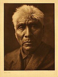
Kaviu, a Pima elder, photographed circa 1907 by Edward S. Curtis.


The Pima /ˈpiːmə (or Akimel O'odham, also spelled Akimel O'otham, "River People", formerly known as Pima) are a group of Native Americans living in an area consisting of what is now central and southern Arizona. Currently, the majority population of the surviving two bands of the Akimel O'odham are based in two reservations: the Keli Akimel O'otham on the Gila River Indian Community (GRIC) and the On'k Akimel O'odham on the Salt River Pima-Maricopa Indian Community (SRPMIC). They are also closely related to other river people, the Ak-Chin O'odham, now forming the Ak-Chin Indian Community, and the Sobaipuri, whose descendants still reside on the San Xavier Indian Reservation or Wa:k (together with the Tohono O'odham) and in the Salt River Indian Community. Together with the kindred Tohono O'odham ("Desert People", formerly known as Papagos) of Eastern Papagueria and the Hia C-ed O'odham ("Sand Dune People", formerly known as Sand Papagos) of the Western Papagueria they form the Upper O'otham or Upper Pima (also known as Pima Alto).

The short name, "Pima" is believed to have come from the phrase pi 'añi mac or pi mac, meaning "I don't know," used repeatedly in their initial meetings with Europeans.

The Akimel O'Otham (anthropologically known as the Pima) are a subgroup of the Upper O'otham or Upper Pima (also known as Pima Alto) whose lands were known in Spanish as Pimería Alta. These groups are culturally related. They are thought to be culturally descended from the group archaeologically known as the Hohokam. The term Hohokam is a derivative of the O'otham word "Huhugam" (pronounced hoo-hoo-gahm) which is literally translated as "those who have gone before" but meaning "The Ancestors".

The Akimel O'otham lived along the Gila River, Salt River, Yaqui River, and Sonora River in ranchería-style villages. The villages were set up as a loose group of houses with familial groups sharing a central ramada and kitchen area with brush olaski's (round houses) surrounding. The O'otham are matrilocal, and familial groups tended to consist of extended families. The Akimel O'otham also lived in temporary field houses seasonally, to tend their crops.

The O'odham language variously called Oʼodham ñeʼokĭ, Oʼodham ñiʼokĭ or Oʼotham ñiok is spoken by all O'odham groups. There are certain dialectal differences, but despite these all O'odham groups can understand one another. There are also some lexicographical differences, especially in reference to newer technologies and innovations.

The economy of the Akimel O'otham was primarily dependent on subsistence, and consisted of farming, hunting and gathering, although there was extensive trading as well. Farming was dependent on an extensive irrigation system that was constructed in prehistoric times[6] and remains in use today. Over time canal systems were built and rebuilt according to the needs of the communities. The Akimel O'otham were experts in the area of textiles and produced intricate baskets as well as woven cloth. Prior to the arrival of Europeans, their primary military rival were the Apache and Yavapai, who raided their villages at times due to competition for resources, although they also established friendly relations with the Apache. Although the Akimel O'otham did have conflicts with other groups they are thought to have been primarily a peaceable people, because they never attacked Euro-American settlers and they were most well known for their aid to immigrants. They did, however, participate in a war cult and had a well-developed battle strategy. Akimel O'otham peoples are also very resilient warriors but only fight when necessary. A specific gene in the Warrior blood allows starvation for prolonged periods of time to be tolerated.The settlement of the city of Phoenix could not have been possible, if not for the Akimel O'otham people defending against the Apache.

The Akimel O'Odham ("River People") have lived on the banks of the Gila River and Salt River since long before European contact.

Their way of life (himdagĭ, sometimes rendered in English as Him-dag) was and is centered on the river, which is considered holy. The term Him-dag should be clarified, as it does not have a direct translation into the English language, and is not limited to reverence of the river. It encompasses a great deal because O'odham him-dag intertwines religion, morals, values, philosophy, and general world view which are all interconnected. Their world view/religious beliefs are centered on the natural world, and this is pervasive throughout their culture.

The Gila and Salt Rivers are currently dry, due to the (San Carlos Irrigation project) upstream dams that block the flow and the diversion of water by non-native farmers. This has been a cause of great upset among all of the O'otham. The upstream diversion in combination with periods of drought, led to lengthy periods of famine that were a devastating change from the documented prosperity the people had experienced until non-native settlers engaged in more aggressive farming in areas that were traditionally used by the Akimel O'otham and Apache in Eastern Arizona. This abuse of water rights was the impetus for a nearly century long legal battle between the Gila River Indian Community and the United States government, which was settled in favor of the Akimel O'otham and signed into law by George W. Bush in December 2005. As a side note, at times during the monsoon season the Salt River runs, albeit at low levels. In the weeks after December 29, 2004, when an unexpected winter rainstorm flooded areas much further upstream (in Northern Arizona), water was released through dams on the river at rates higher than at any time since the filling of Tempe Town Lake in 1998, and was a cause for minor celebration in the Salt River Pima-Maricopa Indian Community. The Salt River Pima-Maricopa Indian Community (SRPMIC) was established on June 14, 1879, and is made of two very distinct Native American tribes: The Pima and the Maricopa. The diversion of the water and the introduction of non-native diet had devastating effects on the health of the people as well. This is said to have been the leading contributing factor in the high rate of diabetes among the Akimel O'otham tribe.

From age ten until the time of marriage, neither boys nor girls were allowed to speak their own names. The Pima Indians believed this would bring bad luck to the children and their future. The names of deceased people were not to be uttered as well. The word or words in the name however are not dropped from the language. Children were given careful oral instruction in moral, religious and other matters. In addition, set speeches, which recited portions of cosmic myth, were a feature of many ceremonies and were especially important in the preparation for war. These speeches were adapted for each occasion but the general context was the same.*

*https://en.wikipedia.org/wiki/Pima_people


KAN


Kin 124: Yellow Resonant Seed


I channel in order to target
Inspiring awareness
I seal the input of flowering
With the resonant tone of attunement
I am guided by the power of intelligence.


The purpose of physical /emotional purification is to attune with the pure electronic plane of the fifth-dimensional being.*


*Star Traveler's 13 Moon Almanac of Synchronicity, Galactic Research Institute, Law of Time Press, Ashland, Oregon, 2015-2016.


The Sacred Tzolk'in 


Visshudha Chakra (Alpha Plasma)


Thursday, April 21, 2016

Blue Rhythmic Night/ Blue Planetary Eagle - Planetary Dog Moon of Manifestation, Day 18


Zuni-girl-with-jar2.png

Zuni girl with jar, 1903.


The Zuni (Zuni: A:shiwi; formerly spelled Zuñi) are a federally recognized Native American tribe, one of the Pueblo peoples. Most live in the Pueblo of Zuni on the Zuni River, a tributary of the Little Colorado River, in western New Mexico, United States. Zuni is 55 km (34 mi) south of Gallup, New Mexico. In addition to the reservation, the tribe owns trust lands in Catron County, New Mexico and Apache County, Arizona. They called their homeland Shiwinnaqin.

Archaeology suggests that the Zuni have been farmers in their present location for 3,000 to 4,000 years. Irrigation agriculture in riverine environments in Zuni began about 3,000 years ago. More recently, Zuni culture seems related to both the Mogollon and Ancestral Pueblo peoples cultures, who lived in the deserts of New Mexico, Arizona, Utah, and southern Colorado for over two millennia. The "village of the great kiva" near the contemporary Zuni Pueblo was built in the 11th century CE. The Zuni region, however, was probably only sparsely populated by small agricultural settlements until the 12th century when the population and the size of the settlements began to increase. In the 14th century, the Zuni inhabited a dozen pueblos between 180 to 1,400 rooms in size. All of these pueblos, except Zuni, were abandoned by 1400, and over the next 200 years, nine large new pueblos were constructed. These were the "seven cities of Cibola" sought by early Spanish explorers. By  1650, there were only six Zuni villages.

In 1539, Moorish slave Estevanico led an advance party of Fray Marcos de Niza's Spanish expedition. The Zuni killed him as a spy.[6] This was Spain's first contact with any of the Pueblo peoples.[7] Francisco Vásquez de Coronado traveled through Zuni Pueblo. The Spaniards built a mission at Hawikuh in 1629. The Zunis tried to expel the missionaries in 1632, but the Spanish built another mission in Halona in 1643.

Before the Pueblo Revolt of 1680, the Zuni lived in six different villages. After the revolt, until 1692, they took refuge in a defensible position atop Dowa Yalanne, a steep mesa 5 km (3.1 miles) southeast of the present Pueblo of Zuni; Dowa means "corn", and yalanne means "mountain". After the establishment of peace and the return of the Spanish, the Zuni relocated to their present location, only briefly returning to the mesa top in 1703.

The Zunis were self-sufficient during the mid-19th century, but faced raiding by the Apaches, Navajos, and Plains Indians. Their reservation was officially recognized by the United States federal government in 1877. Gradually the Zuni farmed less and turned to sheep and cattle herding as a means of economic development.

Frank Hamilton Cushing, a pioneering anthropologist associated with the Smithsonian Institution, lived with the Zuni from 1879 to 1884. He was one of the first participant observers and an ethnologist.

A controversy during the early 2000s was associated with Zuni opposition to the development of a coal mine near the Zuni Salt Lake, a site considered sacred by the Zuni and under Zuni control. The mine would have extracted water from the aquifer below the lake and would also have involved construction between the lake and the Zuni. The plan died in 2003 after several lawsuits.

The Zuni traditionally speak the Zuni language, a language isolate that has no known relationship to any other Native American language. Linguists believe that the Zuni have maintained the integrity of their language for at least 7,000 years. The Zuni have, however, borrowed a number of words from Keresan, Hopi, and Pima pertaining to religion and religious observances. The Zuni continue to practice their traditional religion with its regular ceremonies and dances, and an independent and unique belief system.

The Zuni were and are a traditional people who live by irrigated agriculture and raising livestock. Their success as a desert agri-economy is due to careful management and conservation of resources, as well as a complex system of community support. Many contemporary Zuni also rely on the sale of traditional arts and crafts. Some Zuni still live in the old-style Pueblos, while others live in modern flat-roofed houses made from adobe and concrete block. 

Traditionally, Zuni women made pottery for food and water storage. They used symbols of their clans for designs. Clay for the pottery is sourced locally. Prior to its extraction, the women give thanks to the Earth Mother (Awidelin Tsitda) according to ritual. The clay is ground, and then sifted and mixed with water. After the clay is rolled into a coil and shaped into a vessel or other design, it will be scraped smooth with a scraper. A thin layer of finer clay, called slip, is applied to the surface for extra smoothness and color. The vessel is polished with a stone after it dries. It is painted with home-made organic dyes, using a traditional yucca brush. The intended function of the pottery dictates its shape and images painted on its surface. To fire the pottery, the Zuni used animal dung in traditional kilns. Today Zuni potters might use electric kilns. While the firing of the pottery was usually a community enterprise, silence or communication in low voices was considered essential in order to maintain the original "voice" of the "being" of the clay, and the purpose of the end product. Sales of pottery and traditional arts provide a major source of income for many Zuni people today. An artisan may be the sole financial support for her immediate family as well as others. Many women make pottery, clothing, and baskets.

Religion is central to Zuni life. Their religious beliefs are centered on the three most powerful of their deities: Earth Mother, Sun Father, and Moonlight-Giving Mother, as well as Old Lady Salt and White Shell Woman, as well as other katsinas.

Zunis have a cycle of religious ceremonies. Each person's life is marked by important ceremonies to celebrate the passage of certain life milestones. Birth, coming of age, marriage and death are especially celebrated.

The Zuni make a religious pilgrimage every four years on the Barefoot Trail to Kołuwala:wa, also called Zuni Heaven or Kachina Village; a 12,482-acre (50.51 km2) detached portion of the Zuni Reservation about 60 miles (97 km) southwest of Zuni Pueblo. The four-day observance occurs around the summer solstice. It has been practiced for many hundreds of years and is well known to local residents.

Another pilgrimage conducted annually for centuries by the Zuni and other southwestern tribes is made to Zuni Salt Lake. They harvest salt during the dry months, and celebrate religious ceremonies. The lake is home to the Salt Mother, Ma'l Okyattsik'i, and is reached by several ancient Pueblo roads and trails.

Coming of age, or rite of passage, is celebrated differently by boys and girls. A girl who is ready to declare herself as a maiden will go to the home of her father's mother early in the morning and grind corn all day long. Corn is a sacred food and a staple in the diet of the Zuni. By grinding the corn the girl is declaring that she is ready to play a role in the welfare of her people.

When it is time for a boy to become a man, he will be taken under the wing of a spiritual 'father', selected by the parents. This one will instruct the boy through the ceremony to follow. The boy will go through certain initiation rites to enter one of the men's societies. He will learn how to take on either religious, secular or political duties within that order.


www.wikipedia.com


AKBAL


Kin 123: Blue Rhythmic Night


I organize in order to dream
Balancing intuition
I seal the input of abundance
With the rhythmic tone of equality
I am guided by my own power doubled.


Every humanly created object in the world that we see is a result of a process of visual projection and manifestation.*


*Star Traveler's 13 Moon Almanac of Synchronicity, Galactic Research Institute, Law of Time Press, Ashland, Oregon, 2015-2016.


The Sacred Tzolk'in


Svadhistana Chakra (Kali Plasma)


Wednesday, April 20, 2016

White Overtone Wind/ White Solar Wizard - Planetary Dog Moon of Manifestation, Day 17


Picuris Pueblo, New Mexico.


Picuris comes from the Spanish Picuris, "at the mountain gap." The word "pueblo" comes from the Spanish for "village." It refers both to a certain style of Southwest Indian architecture, characterized by multistory, apartment-like buildings made of adobe, and to the people themselves. Rio Grande pueblos are known as eastern Pueblos; Zuni, Hopi, and sometimes Acoma and Laguna are known as western Pueblos. The people call their pueblo Pingultha, which means either "mountain warrior place" or "mountain pass place."

Location Picuris Pueblo is located on the western slopes of the Sangre de Cristo Mountains, 18 miles south of Taos Pueblo. The average elevation is about 7,000 feet, which makes for a relatively short and somewhat precarious growing season.

People from Picuris spoke a dialect of Northern Tiwa, a Tanoan language.

In the 1200's, the Anasazi abandoned their traditional canyon homelands in response to climatic and social upheavals. A century or two of migrations ensued, followed in general by the slow reemergence of their culture in the historic pueblos. The Tiwas were probably the first of the Tanoan Pueblo people to enter the northern Rio Grande region. Initial settlement of Picuris Pueblo occurred in the twelfth century. It reached its prehistoric peak in the sixteenth century, then declined, probably as a result of the arrival of the Athabaskans.

Picuris joined the Pueblo rebellion of 1680. For years, the Spaniards had routinely tortured Indians for practicing traditional religion. They also forced the Indians to labor for them, sold Indians into slavery, and let their cattle overgraze Indian land, a situation that eventually led to drought, erosion, and famine. Pope of San Juan Pueblo and other Pueblo leaders, including Tupatu or Luis Picuri, planned the great revolt, sending runners carrying cords of maguey fibers to mark the day of rebellion. On August 10, 1680, a virtually united stand on the part of the Pueblos drove the Spanish from the region. The Indians killed many Spaniards but refrained from mass slaughter, allowing most of them to leave Santa Fe for El Paso, Texas.

When the northern pueblos again revolted in 1696, the Picuris abandoned their pueblo and went to live for 20 years on the plains with the Apaches. Between 1680 and 1716, the Picuris population declined by 90 percent. By the 1700's, excluding Hopi and Zuni, only Taos, Picuris, Isleta, and Acoma Pueblos had not changed locations since the arrival of the Spanish. Although Pueblo unity did not last, and Santa Fe was officially reconquered in 1692, Spanish rule was notably less severe from then on. Harsh forced labor all but ceased, and the Indians reached an understanding with the Church that enabled them to continue practicing their traditional religion.

In general, the Pueblo eighteenth century was marked by smallpox epidemics and increased raiding by the Apache, Comanche, and Ute. The people practiced their religion but more or less in secret. During this time, intermarriage and regular exchange between Hispanic villages and Pueblo Indians created a new New Mexican culture, neither strictly Spanish nor Indian, but rather somewhat of a blend between the two. In the early part of the century the Picuris fought with the Spanish against the Apaches, Utes, and Comanches. They also welcomed a French trading party to the pueblo in 1739, having first encountered French goods through trade with Plains tribes 80 years earlier. By the late eighteenth century they had achieved peace with the Comanche. Partly as a result, Spanish settlement grew, and Picuris Pueblo became surrounded by Spanish-Americans.

The relative isolation of Picuris delayed the assimilation pressures faced by other pueblos. However, a government day school, in which children learned Anglo ways and values, opened in 1899. Adults were encouraged to engage in wage work off the pueblo. Timber operations also began, damaging the fragile irrigation system. In an attempt to retain their identity, Pueblo Indians clung even more tenaciously to their heritage, which by now included elements of the once-hated Spanish culture and religion. By the 1880's, railroads had largely put an end to the traditional geographical isolation of the pueblos. Paradoxically, the U.S. decision to recognize Spanish land grants to the Pueblos denied Pueblo Indians certain rights granted under official treaties and left them particularly open to exploitation by squatters and thieves.

www.what-when-how.com


IK


Kin 122: White Overtone Wind


I empower in order to communicate
Commanding breath
I seal the input of spirit
With the overtone tone of radiance
I am guided by the power of heart.


The evolutionary unfolding that we refer to as mind is an intermediate term or medium of learning.*


*Star Traveler's 13 Moon Almanac of Synchronicity, Galactic Research Institute, Law of Time Press, Ashland, Oregon, 2015-2016.


The Sacred Tzolk'in 


Ajna Chakra (Gamma Plasma)


Tuesday, April 19, 2016

Red Self-Existing Dragon/ Red Galactic Skywalker - Planetary Dog Moon of Manifestation, Day 16


Tesuque Pueblo near Santa Fe, NM.


Tesuque is a Hispanicization of the Tewa word tecuge, which means "structure at a narrow place" or "dry, spotted place." 


All Pueblo people are thought to be descended from Anasazi and perhaps Mogollon and several other ancient peoples. From them they learned architecture, farming, pottery, and basketry. Larger population groups became possible with effective agriculture and ways to store food surpluses. Within the context of a relatively stable existence, the people devoted increasing amounts of time and attention to religion, arts, and crafts. In prehistoric times, the Tewa were generally north and west of their present locations and have inhabited numerous prehistoric villages on both sides (though mostly the west side) of the Rio Grande and the Rio Chama.

In the 1200s, the Anasazi abandoned their traditional canyon homelands in response to climatic and social upheavals. A century or two of migrations ensued, followed in general by the slow reemergence of their culture in the historic pueblos. Tesuque Pueblo had at least one (unknown) location previous to its present site, which dates from 1694.

In 1598, Juan de Onate arrived in the area with settlers, founding the colony of New Mexico. Onate carried on the process, already underway in nearby areas, of subjugating the local Indians; forcing them to pay taxes in crops, cotton, and work; and opening the door for Catholic missionaries to attack their religion. The Spanish renamed the Pueblos with saints’ names and began a program of church construction, establishing a mission known as San Lorenzo at Tesuque in the early seventeenth century. At the same time, the Spanish introduced such new crops as peaches, wheat, and peppers into the region. In 1620, a royal decree created civil offices at each pueblo; silver-headed canes, many of which remain in use today, symbolized the governor’s authority.

In 1680 Pueblo Indians organized and carried out a major revolt against the Spanish. For years, the Spaniards had routinely tortured Indians for practicing traditional religion. They also forced the Indians to labor for them, sold Indians into slavery, and let their cattle overgraze Indian land, a situation that eventually led to drought, erosion, and famine. Pope of San Juan Pueblo and other Pueblo religious leaders planned the revolt, sending runners carrying cords of maguey fibers to mark the day of rebellion. The revolt began on August 10, 1680, probably at Tesuque. A virtually united stand on the part of the Pueblos drove the Spanish from the region. The Indians killed many Spaniards but refrained from mass slaughter, allowing them to leave Santa Fe for El Paso.

Mexican "rule" in 1821 brought little immediate change to the Pueblos. The Mexicans stepped up what had been a gradual process of appropriating Indian land and water, and they allowed the nomadic tribes even greater latitude to raid. A political rebellion by Indians and Hispanic poor in 1837 over the issue of taxes led to the assassination of the governor of New Mexico and his brief replacement by a Plains/Taos Indian. As the presence of the United States in the area grew, it attempted to enable the Pueblo Indians to continue their generally peaceful and self-sufficient ways. Paradoxically, however, the U.S. decision to recognize Spanish land grants to the Pueblos denied Pueblo Indians certain rights granted under official treaties and left them particularly open to exploitation by squatters and thieves.

Tesuque ran out of water in the early twentieth century as a result of diversions by recent Anglo settlers. A series of dams and basins restored much of their water by 1935. Partly because of lobbying from the All Indian Pueblo Council, Congress confirmed Pueblo title to their lands in 1924 by passing the Pueblo Lands Act. The United States also acknowledged its trust responsibilities in a series of legal decisions and other acts of Congress. In the late 1950s, Tesuque Pueblo received no tribal income other than the interest from funds on deposit with the government. Since the late nineteenth century, but especially after the 1960s, Pueblos have had to cope with onslaughts by (mostly white) anthropologists and seekers of Indian spirituality. The region is also known for its significant art colonies at Taos and Santa Fe.

Religion In traditional Pueblo culture, religion and life are inseparable. To be in harmony with all of nature is the Pueblo ideal and way of life. The sun is seen as the representative of the Creator. Sacred mountains in each direction, plus the sun above and the earth below, define and balance the Pueblo world. Many Pueblo religious ceremonies revolve around the weather and are devoted to ensuring adequate rainfall. To this end, Pueblo Indians evoke the power of katsinas, sacred beings who live in mountains and other holy places, in ritual and masked dance.

In addition to the natural boundaries, Pueblo Indians have created a society that defines their world by providing balanced, reciprocal relationships within which people connect and harmonize with each other, the natural world, and time itself. According to tradition, the head of each pueblo is the religious leader, or cacique, whose primary responsibility it is to watch the sun and thereby determine the dates of ceremonies. Much ceremonialism is also based on medicine societies, and shamans who derive powers from animal spirits use their supernatural powers for curing, weather control, and ensuring the general welfare. Especially in the eastern pueblos, most ceremonies are kept secret.

At Tesuque, a summer and a winter cacique, appointed for life, oversaw the pueblo. Society was divided into two patrilineal groups, summer (associated with the Squash kiva) and winter (associated with the Turquoise kiva), which united in times of crisis and for the welfare of the Pueblo. These groups were further divided into relatively weak and ill-defined clans. A number of secret societies also existed. For instance, the warrior society was concerned with hunting, war, crops, fertility, and curing. Each society had its own dances and ritual paraphernalia. Numerous life-cycle rites, as well as songs, crafts, communal activities such as maintenance of irrigation canals, prayer retreats, and performing dances, also ensured that one spent one’s life "becoming" a Tewa.

www.what-when-how.com


IMIX


Kin 121: Red Self-Existing Dragon


I define in order to nurture
Measuring being
I seal the input of birth
With the self-existing tone of form
I am guided by the power of navigation.


As the third-dimensional self becomes the artist in charge of creating him/herself and the environment, the fourth-dimensional self becomes the master of the imaginal realm.*


*Star Traveler's 13 Moon Almanac of Synchronicity, Galactic Research Institute, Law of Time Press, Ashland, Oregon, 2015-2016.


The Sacred Tzolk'in


Muladhara Chakra (Seli Plasma)


Monday, April 18, 2016

Yellow Electric Sun/ Yellow Resonant Human - Planetary Dog Moon of Manifestation, Day 15


Church, Pueblo de Taos (Ansel Adams—1941).


Taos Pueblo (or Pueblo de Taos) is an ancient pueblo belonging to a Tiwa-speaking Native American tribe of Pueblo people. It lies about 1 mile (1.6 km) north of the modern city of Taos, New Mexico, USA. The pueblos are considered to be one of the oldest continuously inhabited communities in the United States. This has been designated a UNESCO World Heritage Site.

Taos Pueblo is a member of the Eight Northern Pueblos, whose people speak two variants of the Tanoan language. The Taos community is known for being one of the most private, secretive, and conservative pueblos. A reservation of 95,000 acres (38,000 ha) is attached to the pueblo, and about 4,500 people live in this area

The pueblo was constructed in a setting backed by the Taos Mountains of the Sangre de Cristo Range. The settlement was built on either side of Rio Pueblo de Taos, also called Rio Pueblo and Red Willow Creek, a small stream that flows through the middle of the pueblo compound. Its headwaters come from the nearby mountains.

Taos Pueblo's most prominent architectural feature is a multi-storied residential complex of reddish-brown adobe, built on either side of the Rio Pueblo. The Pueblo's website states it was probably built between 1000 and 1450.

The pueblo was designated a National Historic Landmark on October 9, 1960. In 1992 it was designated as a UNESCO Heritage Site. As of 2006, about 150 people live in the historic complex full-time.

In the Tanoan language of Northern Tiwa, the pueblo is referred to as "the village" in either tə̂otho "in the village" (tə̂o- "village" + -tho "in") or tə̂obo "to/toward the village" (tə̂o- "village" + -bo "to, toward"). The proper name of the pueblo is ȉałopháymųp’ȍhə́othə̀olbo "at red willow canyon mouth" (or ȉałopháybo "at the red willows" for short). This name is more commonly used in ceremonial contexts and is less common in everyday speech.

Most archeologists believe that the Taos Indians, along with other Pueblo Indians, settled along the Rio Grande after migrating south from the Four Corners region. The dwellings of that region were inhabited by the Ancestral Puebloans. A long drought in the area in the late 13th century may have caused them to move to the Rio Grande, where the water supply was more dependable.

Throughout its early years, Taos Pueblo was a central point of trade between the native populations along the Rio Grande and their Plains Tribes neighbors to the northeast. Taos Pueblo hosted a trade fair each fall after the agricultural harvest. www.wikipedia.com


AHAU


Kin 120: Yellow Electric Sun


I activate in order to enlighten
Bonding life
I seal the matrix of universal fire
With the electric tone of service
I am guided by the power of flowering
I am a polar kin
I establish the yellow galactic spectrum.


Creation extends from thought.*


*Star Traveler's 13 Moon Almanac of Synchronicity, Galactic Research Institute, Law of Time Press, Ashland, Oregon, 2015-2016.


The Sacred Tzolk'in 


Sahasrara Chakra (Dali Plasma)


Sunday, April 17, 2016

Blue Lunar Storm/ Blue Rhythmic Monkey - Planetary Dog Moon of Manifestation, Day 14


Tammy Garcia redefines her own image along with the face of Santa Clara Pueblo art. Blue Rain Gallery:

The Pottery of Tammy Garcia, Santa Clara Pueblo, New Mexico.


Santa Clara Pueblo (Tewa: Kha'po) is a census-designated place (CDP) in Rio Arriba County, New Mexico, United States. The population was 980 at the 2000 census, although, approximately 3,800 reside on the reservation. Santa Clara Pueblo was established about 1550.

The pueblo is a member of the Eight Northern Pueblos, and the people are from the Tewa ethnic group of Native Americans who speak the Tewa language. The pueblo is on the Rio Grande, between Ohkay Owingeh (formerly San Juan Pueblo) to the north and San Ildefonso Pueblo to the south. Santa Clara Pueblo is famous for producing hand-crafted pottery, specifically blackware and redware with deep engravings. The pueblo is listed on the National Register of Historic Places.

Pueblo peoples lived in the area for millennia before they met Juan de Oñate and his exploration party on July 11, 1598.[3] Pueblo archaeology shows that Ancient Pueblo Peoples lived in the general region as far back as 1200BC.

First visited in 1541, a segment of Francisco Vásquez de Coronado's expeditionary force met with the residents of the nearby Caypa pueblo. After annexation of the region into the Spanish Kingdom, and as part of the 1601 expansion of Oñate's colonial capital,[4] a chapel was built there by 1617. Fray Alonso de Benavides established a mission in 1628.

History shows that the mission was abandoned on the lead up to the revolt. The pueblo would join forces with others and would fight against the Spanish royal government in 1680 in the Great Pueblo Revolt. The original and unoccupied chapel was destroyed. Two other chapel buildings would be constructed there. The current church replaced the former in 1918. In 1782, a small pox outbreak decimated the population. The eighth section of the Act of July 22, 1854 mandated a census of the newly acquired possessions of the US government. In review of the land's title, the pueblo presented a Spanish Royal decree dated October 15, 1713 that the title to land and various pueblos could be expected. Though lost, the decree on the title papers, if ever they existed, assured protection of the pueblos' right to protection of their homelands from encroachment. The result of the title research led the pueblo community to be of the first recognized by Congress.

Santa Clara Pueblo, "Kha-'Po Owingeh" (Singing Water Village) is a Tewa tribe located twenty-five miles north of Santa Fe, New Mexico on the west bank of the Rio Grande. Tewa oral history tells of an emergence of the Tewa to the north, in the Mesa Verde-Chaco area. The Tewa moved south over time and occupied large regions of present-day New Mexico in many villages. Each of the villages remained independent of each other, operating as separate tribes with similar cultures. Santa Clara people trace their ancestors to many prehistoric villages and cliff dwellings west of the current village. The Puye Cliff Dwellings is one of many of these sites and was occupied from around 700 A.D. to the late 1300s. The current Pueblo of Santa Clara was established sometime between the late 1300s and early 1400s.

Spanish explorers came in contact with the village for the first time during the Coronado Expedition (1540-1542). The Spanish did not return to stay until 1598, when Don Juan de Onate invaded the Pueblo region and established a permanent settlement near the present-day Tewa village of Ohkay-Owingeh. In 1610, that settlement was abandoned and the Spanish headquarters was moved near Tano villages at present-day Santa Fe. Under increasing religious persecution, the Pueblo people joined together and revolted against Spanish rule on August 10, 1680. The Spanish were thrown out of New Mexico and did not return until 1692, when Diego de Vargas re-conquered the Pueblos. Santa Clara Pueblo DrawingHowever, residents from Santa Clara and other Tewa Pueblos refused to surrender and took refuge on Black Mesa near present-day San Ildefonso Pueblo. After a nine month siege and multiple assaults, de Vargas was finally able to defeat the Tewas in 1694. After the Reconquest, the Spanish no longer persecuted Pueblo religion to the same extent as before. Pueblo lands were protected as land grants under Spanish and Mexican rule. Their lands were further preserved under the Treaty of Guadalupe Hidalgo (1848), when New Mexico came under United States rule.

Currently Santa Clara Pueblo has approximately 1,000 residents. The Puye Cliff Dwellings and the Santa Clara Canyon are currently closed to the public due to the devastating Cerro Grande Fire of 2000. The tribe operates a casino, golf course, and a travel center. Annual feast days with traditional dances are open to the public on Santa Clara Feast Day (August 12), and San Antonio Day (June 13).
www.wikipedia.com/ www.roxanne swentzell.com


CAUAC


Kin 119: Blue Lunar Storm


I polarize in order to catalyze
Stabilizing energy
I seal the matrix of self-generation
With the lunar tone of challenge
I am guided by the power of magic.


Appreciation is a supreme magnet: the greater your appreciation, the more is given to you.*


*Star Traveler's 13 Moon Almanac of Synchronicity, Galactic Research Institute, Law of Time Press, Ashland, Oregon, 2015-2016,


The Sacred Tzolk'in 


Anahata Chakra (Silio Plasma)


Saturday, April 16, 2016

White Magnetic Mirror/ White Overtone Dog - Planetary Dog Moon of Manifestation, Day 13


Wright's Indian Art: Wood and Straw Work Cross  by Carlton Gallegos
Wood and straw work wooden cross, Carlton Gallegos, Santa Ana Pueblo, NM.


Santa Ana Pueblo (Eastern Keres: Tamaiya) is a census-designated place (CDP) in Sandoval County, New Mexico, United States. As of the 2000 census, the CDP had a total population of 479. It is part of the Albuquerque Metropolitan Statistical Area. The Pueblo, named Tamaya in the native language, administers a total reservation land of 73,000 acres (295 km2) in the Rio Grande valley and is composed of Native Americans who speak an eastern dialect of the Keresan languages.

Santa Ana people call their Old Pueblo Tamaya. The word "pueblo" comes from the Spanish for "village." It refers both to a certain style of Southwest Indian architecture, characterized by multistory, apartment like buildings made of adobe, and to the people themselves. Rio Grande pueblos are known as eastern Pueblos; Zuni, Hopi, and sometimes Acoma and Laguna are known as western Pueblos.

White historians are wrong about many facts regarding pueblo Indians including the Santa Ana Indian Tribe of New Mexico. The highly advanced Pueblo Indians civilization was the most advanced known Indian civilization of the Americas. They are probably related to the Apache and Navajo who are an admixture of Anishinaabe, other eastern tribes, and Pueblo Indians. These supposed Athabascan people live in the southwestern United States and northern Mexico. Apache Indians are closely related to the Navajo, and some even suggest that the most westerly Apaches are in fact Navajo. They claim that the western Apache language is closely related to the language of the Navajo. Since there are Athabascan tribes who have a totemic system, all Athabascan tribes are closely related to the Anishinabek, and all other Algonquian tribes of the eastern United States, where the totemic system was a major part of daily life.  Both the Apache Indians and Navajo, have every reason to claim that the ancient civilized ruins located in Arizona, Colorado, New Mexico, and Utah are the ruins of their ancestors' civilized settlements. Thus, the Apache Indians and the Navajo are closely related to the Pueblo Indians of Arizona and New Mexico. The Apache, Navajo, and Pueblo Indians all have a degree of Anishinaabe blood.

In general, the Pueblo eighteenth century was marked by smallpox epidemics and increased raiding by the Apache, Comanche, and Ute. Occasionally Pueblo Indians fought with the Spanish against the nomadic tribes. The people practiced their religion but more or less in secret. During this time, intermarriage and regular exchange between Hispanic villages and Pueblo Indians created a new New Mexican culture, neither strictly Spanish nor Indian, but rather somewhat of a blend between the two. Santa Anas began buying and cultivating fields at Ranchitos and spent more and more time there into the next century. www.wikipedia.com


ETZNAB


Kin 118: White Magnetic Mirror


I unify in order to reflect
Attracting order
I seal the matrix of endlessness
With the magnetic tone of purpose
I am guided by my own power doubled.


Our life and everything we see in the phenomenal world is the articulation of specific cycles of time.*


*Star Traveler's 13 Moon Almanac of Synchronicity, Galactic Research Institute, Law of Time Press, Ashland, Oregon, 2015-2016.


The Sacred Tzolk'in 


Manipura Chakra (Limi Plasma)