Thursday, April 7, 2016

Red Overtone Moon/ Red Solar Dragon - Planetary Dog Moon of Manifestation, Day 4


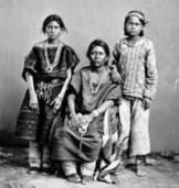
Tuvahe, photographed at Jemez Pueblo by Edward S. Curtis.


The Pueblo of Jemez (pronounced "Hay-mess" or traditionally as "He-mish") is one of the 19 pueblos located in New Mexico. It is a federally recognized American Indian tribe with 3,400 tribal members, most of whom reside in a puebloan village that is known as "'Walatowa" (a Towa word meaning "this is the place"). Walatowa is located in North-Central New Mexico, within the southern end of the majestic Canon de Don Diego. It is located on State Road 4 approximately one hour northwest of Albuquerque (55 miles) and approximately one hour and twenty minutes southwest of Santa Fe.

The Pueblo of Jemez is an independent sovereign nation with an independent government and tribal court system. The secular Tribal Government includes the Tribal Council, the Jemez Governor, two Lt. Governors, two fiscales, and a sheriff. Interestingly, for reasons discussed later, our 2nd Lt. Governor is also the governor of the Pueblo of Pecos. Traditional matters are still handled through a separate governing body that is rooted in prehistory. This traditional government includes the spiritual and society leaders, a War Captain and Lt. War Captain. Through perseverance, our people have managed to preserve our traditional culture, religion, and knowledge of our ancient traditional ways regardless of outside pressures. We have also preserved our complex traditional language, a language the anthropologists and linguists refer to as "Towa". Jemez is the only culture that speaks this language, and our traditional law forbids our language from being translated into writing in order to prevent exploitation by outside cultures.

Having originated from a place called "Hua-na-tota," our ancestors, the Jemez Nation, migrated to the "Canon de San Diego Region" from the four-corners area in the late 13th century. By the time of European contact in the year 1541, the Jemez Nation was one of the largest and most powerful of the puebloan cultures, occupying numerous puebloan villages that were strategically located on the high mountain mesas and the canyons that surround the present pueblo of Walatowa. These stone-built fortresses, often located miles apart from one another, were upwards of four stories high and contained as many as 3,000 rooms. They now constitute some of the largest archaeological ruins in the United States. Situated between these "giant pueblos" were literally hundreds of smaller one and two room houses that were used by the Jemez people during spring and summer months as basecamps for hunting, gathering, and agricultural activities. However, our spiritual leaders, medicine people, war chiefs, craftsmen, pregnant women, elderly and disabled lived in the giant pueblo throughout the year, as warriors and visitors could easily reach at least one of the giant pueblos within an hours walk from any of the seasonal homes. In addition, impenetrable barriers were established with cliffs to guard access to springs and religious sites, to monitor strategic trail systems, and to watch for invading enemies. In general, the Jemez Nation resembled a military society that was often called upon by other tribal groups to assist in settling hostile disputes.

Our people experienced their first contact with Europeans in the form of Spanish conquistadors in the year of 1541. When the Coronado Expedition entered into the area, exactly 40 peaceful years went by before contact between the two groups was experienced again. The Rodriquez-Chamuscado Expedition entered the area in 1581, followed by the Espejo Expedition in 1583. In the year 1598, a detachment of the first colonized expedition under the direction of Don Juan de Onate visited the Jemez. A Franciscan priest by the title of Alonzo de Lugo was assigned to our people and he had our people build the area's first church at the Jemez Pueblo of Guisewa (now Jemez State Monument on State Highway 4 in Jemez Springs). According to our intricate oral history, as well as early written Spanish records (Espejo Expedition 1583), the Jemez nation contained an estimated 30,000 tribal members around the time of the Spanish contact, indicating that the population of the Canon de San Diego was probably three times larger than what it is today. Unfortunately, the peace between differing cultures did not last long and the Jemez population soon became decimated as a result of warfare and diseases introduced by the Europeans.

During the next 80 years, numerous revolts and uprisings occurred between the Jemez people and Spanish, primarily due to Spanish attempts to Christianize our people by force, and congregate them into just one or two villages, where the Franciscan missions were located. As a result, numerous people were killed on both sides, including many of the Franciscan priests. By the year 1680, the hostilities resulted in the Great Pueblo Revolt, during which the Spanish were expelled from the New Mexico Province through the strategic and collaborative efforts of all the Puebloan Nations. This was the first and only successful revolt in the United States in which a suppressive nation was expelled. By 1688, the Spanish had begun their reconquest in force under General Pedro Reneros de Posada, acting Governor of New Mexico. The Pueblos of Santa Ana and Zia were conquered, and by 1692, Santa Fe was again in Spanish hands under Governor Diego de Vargas. Four more years would pass before the Jemez Nation was completely subdued and placed under clergy and military rule. Our ancestors were moved and concentrated into the single Village of Walatowa where we presently reside today. As a result, the most significant of our ancestral sites are now located just out of view of the Pueblo on federal lands and are no longer controlled by our people. Regardless, our ancestral lands are still held in the highest esteem by the Jemez people and not a week goes by that they are not paid tribute to through our prayers and religious offerings. wwwjemezpueblo.com


MULUC


Kin 109: Red Overtone Moon


I empower in order to purify
Commanding flow
I seal the process of universal water
With the overtone tone of radiance
I am guided by the power of navigation
I am a galactic activation portal
Enter me.


The purpose of the projecting capacity is to manifest increasingly ideal conditions for realizing ever more evolved states of being and consciousness.*


*Star Traveler's 13 Moon Almanac of Synchronicity, Galactic Research Institute, Law of Time Press, Ashland, Oregon, 2015-2016.


The Sacred Tzolk'in 


Svadhistanha Chakra  (Kali Plasma)


Wednesday, April 6, 2016

Yellow Self-Existing Star/ Yellow Galactic Sun - Planetary Dog Moon of Manifestation, Day 3


Isleta Pueblo Pottery. Lucero.


Pueblo of Isleta (or Isleta Pueblo), is known as Shiewhibak in their Isletan Tiwa language, meaning "flint kick-stick place". It is an unincorporated community Tanoan pueblo in Bernalillo County, New Mexico, United States, originally established around the 14th century. Its people are federally recognized as a Native American tribe.

Pueblo of Isleta is located in the Middle Rio Grande Valley, 13 miles (21 km) south of Albuquerque. It is adjacent to and east of the main section of Laguna Pueblo. The pueblo was built on a knife-shaped reef of lava running across an ancient Rio Grande channel. The Isleta Pueblo Historic District is listed on the National Register of Historic Places.

On January 15, 2016, the tribe's officials and federal government representatives held a ceremony to mark the government's taking into federal trust some 90,151 acres of land, 140 square miles, which the Pueblo had purchased. It enlarged their communal territory by 50%. The tribe had worked for more than 20 years to acquire this land, once part of their homeland. It is so far the largest such acquisition handled under the President Barack Obama administration.

The population of Pueblo of Isleta consists of mostly the Southern Tiwa ethnic group (Spanish: Tigua.). They speak Isletan Tiwa, one of the two varieties or dialects of the Southern Tiwa language, part of the Tanoan language family. The other variety is spoken at Sandia Pueblo. In August 2015, the tribe announced that the Tiwa language would be taught to children at Isleta Elementary School, following the school's transfer from federal to tribal control.

Isleta (and the Sandia) have matrilineal endogamous corn groups, with descent traced through the mother's family; children are considered born to her people. These kinship and cultural divisions are connected with sacred directions and colors, as well as tribal [[Kinship#Lineages, clans, phratries, moieties, and a matrimonial sides|moiety]] system (one moiety connected with the winter, the other with the summer). The tribe also has a kiva system.

In the early 20th century, the tribe was headed by a cacique, selected by elders from a clan with hereditary rights. In addition, the tribe elected a governor and assistants. The grand council was made up of chiefs, respected leaders of the pueblo. There were distinctions between peace chiefs and those leaders appointed in war.

Kachina cults are found in Isleta. They may have adopted this cult from Laguna people of the Western Pueblos, which have historically practiced such cults for a longer period.

Isleta, or Shiewip, is situated on the Rio Grande at what once was the intersection of important north-south and east-west Pueblo roads. The north-south route later became the Spanish Camino Real, or “Royal Road,” making Isleta an important settlement at the crossroads of both Pueblo and Spanish trade routes. As a large town, Isleta was also a central gathering place for the surrounding smaller villages in the area, servicing as a cultural capital for other Tiwa communities and the Piro and Tompiro-speaking villages to the south and east. As most of these smaller communities collapsed during the early Spanish Colonial period, many of their residents resettled at Isleta.

Over the course of 3,000 years, the Pueblo peoples developed agricultural practices suitable to the harsh environment of the American Southwest. In later centuries, Isleta irrigated land along the Rio Grande, where they grew maize, beans, squash and cotton. These practices continued throughout the 250 years of Spanish rule, which began in 1598, and survived through the beginning of the American acquisition of New Mexico.

By the 19th century, visitors to Isleta found a prosperous farming community with well-tended agricultural fields, irrigation canals, vineyards and orchards. In addition, the people of Isleta developed a wide trading network, regularly engaged in hunting buffalo and other game and gathered plants and minerals over a vast region. During this time, a number of community members became quite affluent.

The Pueblo of Isleta became a favored destination of many 19th century American travelers, scientists and linguists. As a result, Isletan ritual observances and ways of life were documented, with varying degrees of success. Individuals who were to become the vanguards of anthropology and archaeology began to appear at the Pueblo. Among them, Adolph Bandelier, one of the founders of Southwestern archeology, as well as a precise and avid historian, was a frequent visitor. Another important contributor to the historic record of Isleta was Charles Fletcher Lummis, an early champion of Native American rights. He arrived at Isleta in 1889 and resided there until 1892.

The Pueblo of Isleta remains a traditional society today. The town of Isleta, located 13 miles south of present day Albuquerque, has a resident population of almost 5,000. They continue to speak their native language, Southern Tiwa, as well as English, and adhere to and participate in the yearly cycle of ceremonial events. They continue ancient practices at home. They live as Americans in the outside world and connect with our ancestors in our village. www.wikipedia.com, www.isleta.com


LAMAT


Kin 108: Yellow Self-Existing Star


I define in order to beautify
Measuring art
I seal the store of elegance
With the self-existing store of form
I am guided by the power of flowering
I am a galactic activation portal
Enter me.


With practice you can discipline yourself in order to make your spiritual nature more evident.*


*Star Traveler's 13 Moon Almanac of Synchronicity, Galactic Research Institute, Law of Time Press, Ashland, Oregon, 2015-2016.


The Sacred Tzolk'in 



Ajna Chakra (Gamma Plasma)


Tuesday, April 5, 2016

Blue Electric Hand/ Blue Resonant Storm - Planetary Dog Moon of Manifestation, Day 2


Petroglyphs by Hohokam People in Saguaro National Park


The Hohokam (/hoʊhoʊˈkɑːm/) were an ancient Native American culture centered on the present-day US state of Arizona. The Hohokam are one of the four major cultures of the American Southwest and Northern Mexico in Southwestern archaeology. Considered part of the Oasisamerica tradition, the Hohokam established significant trading centers such as at Snaketown and are considered to be the builders of the original canal system around the Phoenix metropolitan area.

According to local oral tradition, the Hohokam may be the ancestors of the historic Pima and Tohono O'odham peoples in Southern Arizona. Recent academic research focused on the Sobaipuri, ancient ancestors of the modern Pima, indicates that Pima groups were present in the region at the end of the Hohokam sequence.

Hohokam, a term borrowed from the O'odham language, is used to define an archaeological culture that existed from the beginning of the common era to about the middle of the 15th century. As an abstract construct, this culture was centered on the middle Gila and lower Salt River drainages in what is known as the Phoenix basin. This is referred to as the Hohokam Core Area, as opposed to the Hohokam Peripheries; or adjacent regions into which the Hohokam Culture extended. Collectively, the Core and Peripheries formed what is referred to as the Hohokam Regional System, which occupied the northern or Upper Sonoran Desert in what is now Arizona. The Hohokam also extended into the Mogollon Rim region.

Within a larger context, the Hohokam culture area inhabited a central trade position between the Patayan situated along the Lower Colorado River and in southern California; the Trincheras of Sonora, Mexico; the Mogollon culture in eastern Arizona, southwest New Mexico, and northwest Chihuahua, Mexico; as well as the Ancestral Puebloans in northern Arizona, northern New Mexico, southwest Colorado, and southern Utah.

In North America, the Hohokam were the only culture to rely on irrigation canals to water their crops since as early as 800, and their irrigation systems supported the largest population in the Southwest by 1300. Archaeologists working at a major archaeological dig in the 1990s in the Tucson Basin, along the Santa Cruz River, identified a culture and people that were ancestors of the Hohokam that might have occupied southern Arizona as early as 2000 BCE. This prehistoric group from the Early Agricultural Period grew corn, lived year round in sedentary villages and developed sophisticated irrigation canals.

The Hohokam used the waters of the Salt and Gila Rivers and constructed an assortment of simple canals combined with weirs in their various agricultural pursuits. Since the 9th century and extending into the 15th century, they maintained what was to become extensive irrigation networks that rivaled the complexity of those used in the ancient Near East, Egypt, and China. These were constructed using relatively simple excavation tools, without the benefit of advanced engineering technologies, and achieved drops of a few feet per mile, balancing erosion and siltation. Over 70 years of archaeological research has revealed that the Hohokam cultivated varieties of cotton, tobacco, maize, beans and squash, as well as harvested a vast assortment of wild plants. Late in the Hohokam Chronological Sequence, they also used extensive dry-farming systems, primarily to grow agave for food and fiber. Their reliance on agricultural strategies based on canal irrigation, vital in their less than hospitable desert environment and arid climate, provided the basis for the aggregation of rural populations into stable urban centers.

Overall, Hohokam villages and smaller settlements can be classified within the ranchería-tradition; these typically found near water and arable land, and identified by clusters of residential areas composed of discrete groups of habitation and utility structures combined with extramural use areas. Many features of early Hohokam domestic architecture, such as large square or rectangular pithouses, seem to have been transplanted relatively intact from early Formative Period examples first developed in the Tucson basin. But, by the seventh century, a distinct Hohokam architectural tradition emerged. Throughout the Hohokam Chronological Sequence, individual residential structures were normally excavated approximately 40 cm (16 in) below ground level, with plastered or compacted floors that covered between 12 and 35 m2, and featured a circular, bowl-shaped, clay-lined hearth situated near the wall-entry.

Hohokam burial practices varied over time. Initially, the primary method employed was flexed inhumation, similar to the tradition used by the southern Mogollon Culture, located immediately to the east. In the late Formative and Preclassic periods, the Hohokam cremated their dead, again strikingly similar to the traditions documented among the historic Patayan Culture situated to the west along the Lower Colorado River. Although the particulars of the practice changed somewhat, the Hohokam cremation tradition remained dominant until around 1300. At this time extended inhumation, similar to that used by the Salado tradition to the north and northeast, was quickly adopted. Also of interest, many of the details of the late Hohokam burial patterns were very similar to the tradition practiced by the historic Tohono and Akimel O'odham. www.wikipedia.com


MANIK


Kin 107: Blue Electric Hand


I activate in order to know
Bonding healing 
I seal the store of accomplishment
With the electric tone of service
I am guided by the power of magic.


Other dimensions of experience exist of which we are currently unaware.*


*Star Traveler's 13 Moon Almanac of Synchronicity, Galactic Research Institute, Law of Time Press, Ashland, Oregon, 2015-2016.


The Sacred Tzolk'in 


Muladhara Chakra (Seli Plasma)


Monday, April 4, 2016

White Lunar World-Bridger/ White Rhythmic Mirror - Planetary Dog Moon of Manifestation, Day 1


Group of Nine Havasupai Girls, ca. 1898; George Wharton


The Havasupai people (Havasupai: Havsuw’ Baaja) are an American Indian tribe who have lived in the Grand Canyon for at least the past 800 years. Havasu means “blue-green water” and pai “people”.

Located primarily in an area known as Cataract Canyon, this Yuman-speaking population once laid claim to an area the size of Delaware. In 1882, however, the tribe was forced by the federal government to abandon all but 518 acres of its land. A silver rush and the Santa Fe Railroad in effect destroyed the fertile land. Furthermore, the inception of the Grand Canyon as a national park in 1919 pushed the Havasupai to the brink, as their land was consistently being used by the National Park Service. Throughout the 20th century, the tribe used the US judicial system to fight for the restoration of the land. In 1975, the tribe succeeded in regaining approximately 185,000 acres of their ancestral land with the passage of the Grand Canyon National Park Enlargement Act.

The tribe had traditionally relied heavily on agriculture, hunting and gathering as their means of survival. Although living primarily above and inside the Grand Canyon, which consists mostly of harsh terrain, the tribe’s reservation was also home to some lush vegetation and beautiful waters. Their name, meaning “the People of the Blue-Green Waters,” reflects this.

The Havasupai are said to have existed within and around the Grand Canyon for over eight centuries. Little is known about the tribe prior to their first recorded European encounter in 1776 with Spanish priest Francisco Garces. Garces reported seeing roughly 320 individuals in his time with the Havasupai, a number that would diminish over the centuries as westward expansion and natural catastrophes significantly decreased the population size, before rising to approximately 650 in the current era.

In the first half of the 19th century, with exception to the introduction of horses by the Spanish, U.S. westward expansion affected the Havasupai less than it did other indigenous populations of the west. Even as interaction with settlers slowly increased, day-to-day life did not change much for the tribe until silver was discovered in 1870 by Cataract Creek. The migration of prospectors to the area was unwelcome. The Havasupai sought protection from the intrusion of western pioneers on their land and sought out assistance, but to little avail. An executive order by President Rutherford Hayes in 1880 established a small federally protected reservation for the tribe, yet it did not include the mining areas along the Creek.

During this era, Havasupai relations with other Native American tribes were generally mixed. Bonds and interactions with the Hopi tribe, whose reservation was in close proximity, were strong, as the two peoples did a great deal of trading with each other. The Hopi introduced crops such as the gourd and sunflower that would eventually become a staple of the Havasupai diet. Still, the Havasupai were not without enemies as they were consistently at odds with the Yavapai and the Southern Paiute, who would steal and destroy crops planted by the Havasupai.

In 1882 President Chester A. Arthur issued an executive order that all land on the plateau of the canyon, which was traditionally used for winter homes for the tribe, was to become public property of the United States. The order in effect relegated the Havasupai to a 518-acre (2.10 km2) plot of land in Cataract Canyon, taking almost all of their aboriginal land for American public use. According to reports, the Havasupai were completely unaware of the act for several years.

The loss of almost all of their land was not the only issue that the Havasupai were contending with: the increase in the number of settlers in the local region had depleted game used for hunting, and soil erosion (a result of poor irrigation techniques) touched off a series of food shortages. Furthermore, interaction with the settlers sparked deadly disease outbreaks amongst tribe members, who were ravaged by smallpox, influenza, and measles. By 1906 only 166 tribal members remained – half the number Garces saw when he first came across the tribe in 1776.

In the 1800s the continental railway system was greatly expanded. In 1897 construction opened on a spur line of the Santa Fe Railroad, which was to lead directly to the Grand Canyon; by 1901 the line was open. During his visit to the Grand Canyon in 1903, President Theodore Roosevelt met two Havasupais at Indian Garden. Roosevelt told them about the park that was being created, and that they would have to leave the area. In 1908 the Grand Canyon was declared a national monument, and by 1919 it had received National Park status. However, it was not until 1928 that the Havasupai finally left Indian Garden, forced out by the National Park Service.

Prior to modern times agriculture was the essential means of progress and survival for the Havasupai. While in the winter the tribe members stationed themselves on the plateau of the canyon, in the summer irrigation gardening of the crop fields brought the members back inside the canyon walls. As vast and uneven as the Grand Canyon is, it is somewhat of an anomaly that the Havasupai were able to agriculturally sustain and thrive in such a voluminous landscape. Because of a lack of available soil rich in nutrients, it has been suggested that the tribe cultivated only 200 acres (0.81 km2) of land on the canyon floor. Although lacking space, the tribe’s irrigation technology was far more advanced than others in the Southwest which allowed them to be agriculturally intensive. However, being located at the bottom of a canyon left the fields vulnerable to flooding as a result of rain and the overflowing of Cataract Creek, as was the case in 1911 when almost an entire crop field was destroyed. In 1920 to combat the issue the federal government assisted the tribe in constructing a new irrigation system which was generally effective in ceasing soil erosion from water overflows.

Historically the main crops for the Havasupai were corn, beans, squash, sunflowers, gourds, and some cotton. Corn, the tribe’s main crop, was generally harvested in the later summer months. While growing, a farming technique called cepukaka was used to protect the corn from being blown over when it got to a certain height. In this technique, a farmer loosened the soil around the corn and then pulled it into a hill around the stalk base. Along with their traditional crops, the Havasupai were introduced to melons, watermelons, and orchard trees with the arrival of the Spanish. By the 1940s these crops had become staples of the Havasupai diet. www.wikipedia.com


CIMI


Kin 106: White Lunar World-Bridger


I polarize in order to equalize
Stabilizing opportunity
I seal the store of death
With the lunar tone of challenge
I am guided by the power of endlessness
I am a galactic activation portal 
Enter me.


The law of physical manifestation is micro-principle of the conscious stage of the self-evolution of the universe as a work of art.*


*Star Traveler's 13 Moon Almanac of Synchronicity, Galactic Research Institute, Law of Time Press, Ashland, Oregon, 2015-2016.


The Sacred Tzolk'in 


Sahasrara Chakra (Dali Plasma)


Sunday, April 3, 2016

Red Magnetic Serpent/ Red Overtone Earth - Solar Jaguar Moon of Intention, Day 28


1920's Hualapai Storage Basket.


The Hualapai or Walapai (Hualapai: Hwalbáy) are a tribe of Native Americans who live in the mountains of northwestern Arizona, United States. Today they are enrolled in the Hualapai Indian Tribe of the Hualapai Indian Reservation.

The name, meaning "people of the tall trees", is derived from hwa:l, the Hualapai word for ponderosa pine and pai “people”. Their traditional territory is a 108-mile (174 km) stretch along the pine-clad southern side of the Grand Canyon and the Colorado River with the tribal capital located at Peach Springs.

The Hualapai language is a Pai branch of the Yuman–Cochimí languages, also spoken by the closely related Havasupai, and more distantly to Yavapai people. It is still spoken by most people over 30 on the Reservation as well as many young people. The Peach Springs School District runs a successful bilingual program for all local students, both Hualapai and non-Hualapai, in addition to immersion camps.

The Hualapai Reservation, established in 1883, is located on one million acres of Hualapai ancestral lands, within the southern portion of the Colorado Plateau and the Grand Wash Cliffs escarpment. Hualapai, meaning “People of the tall-pines,” had ancestral homelands consisting of approximately five million acres. The modern northern boundary of the reservation is along the Grand Canyon and the Colorado River. Wikame is the Sacred Mountain of Creation for Hualapai people. It is along the
lower Colorado River and at an altitude of more than 5900 feet. 

According to Hualapai oral tradition, Hualapai Bands were entrusted within the Hualapai Nation with care taking responsibilities for the natural environment and resources within the traditional and ancestral Hualapai homelands and territory. Neighboring American Indian Nations and Tribes are: Chemehuevi, Havasupai, Hopi, Navajo, Mohave, Paiute, Yavapai-Prescott, Yavapai-Apache, Colorado River Indian Tribes and Zuni. Relationships with other tribes continues in spite of late nineteenth and twentieth century actions of paternalism, attempted assimilation and dislocation, the Hualapai system of bands and social organization remains in effect, maintained through descent and kinship linkages. Traditional cultural practises applied through continuity of Hualapai language, knowledge, social roles and behaviors, supports a dynamic cultural identity manifested within Hualapai people and their spiritual connection to their land.

Seasonal migrations for hunting and gathering of sustenance resulted in acquiring a variety of foods that extended through different elevations and geographic locations. Spiritual and life skills were conveyed partially during these migration events with Hualapai teaching their children traditional
knowledge through hunting and gathering, song and oration, and environmental stewardship. 

All of the Bands of the Hualapai Nation have used the natural and cultural resources of the Colorado River and Grand Canyon systems from the time of the Hualapai people’s origins. Hualapai traditional belief ties sacred significance to areas such as the Colorado River and associated canyons which are principal landmarks with intrinsic spiritual values for Hualapai people. Regionally this area embodies sacred esoteric cultural and traditional values for Hualapai. The Colorado River is revered as a life-giving source, known as “Ha’yiđađa,” the backbone or spine of the river. It is the belief that without the spine, Hualapai cannot survive as a people. The long expanse of the River through the canyon and the riparian eco-systems makes a life way connection that flows through the hearts of the Hualapai people. The Hualapai maintain this connection through ties of sacredness to the Colorado River. Hualapai believe that they were created from the sediment and clay of the River. 

 In 1874 life completely changed for Hualapai. The U.S. Army at the instructions of the Bureau of Indian Affairs (BIA) removed Hualapai “from their homes against their will and sent them south to bake in the desert of the Colorado River lowlands, a place the officer in charge called the “Sahara of the Colorado,”  Hualapai were forced to march down on a long-walk, or Trail of Tears, to La Paz, near the town of present-day Ehrenberg and live within the confines of a “camp.”  Many young women were assaulted by the military; older Hualapai  died due to hunger and ill-health; many died due to exposure, malnutrition, home-sickness and disease. Some fled into the desert making their way
into Borrego Springs and California.  Others managed to survive and after a year of incarceration, those who could went back to their homes only to find their lands occupied by ranchers. 
www.wikipedia.com, www.hualapai-nsn.gov


CHICCHAN


Kin 105: Red Magnetic Serpent


I unify in order to survive
Attracting instinct
I seal the store of life force
With the magnetic tone of purpose
I am guided by my own power doubled.


Only when you learn to control your thought-waves will you experience that which is called "abiding in the real."*


*Star Traveler's 13 Moon Almanac of Synchronicity, Galactic Research Institute, Law of Time Press, Ashland, Oregon, 2015-2016.


The Sacred Tzolk'in 


Anahata Chakra (Silio Plasma)


Saturday, April 2, 2016

Yellow Cosmic Seed/ Yellow Self-Existing Warrior - Solar Jaguar Moon of Intention, Day 27


Native American Vase from the Southwest:

Native American Pottery from the Southwest.


The Halchidhoma (Maricopa: Xalychidom Piipaa or Xalychidom Piipaash -'people who live toward the water') are an Indian tribe now living mostly on the Salt River reservation, but formerly native to the area along the lower Colorado River in California and Arizona when first contacted by Europeans. In the early nineteenth century, under pressure from their hostile Mohave and Quechan neighbors, they moved to the middle Gila River, where some merged with the Maricopa, and others went on to Salt River and maintained an independent identity.

The Halchidhoma entered written history in 1604-1605, when a Spanish expedition coming overland from New Mexico under Juan de Oñate encountered the "Alebdoma" on the lower Colorado River, below its junction with the Gila River. When the Jesuit missionary-explorer Eusebio Francisco Kino returned to the river in 1700, the Halchidhoma had moved to a portion of the river 100 miles farther north.

A system of military alliances and traditional hostilities seems to have prevailed among the relatively warlike tribes of the lower Colorado and Gila rivers. This may account for the Halchidhoma's move during the seventeenth century. The Halchidhoma were part of an alliance that also included the Maricopa and Cocopa, among others, and was opposed by the Quechan and Mohave. In the 1820s, the Halchidhoma were finally driven from the Colorado River. They took refuge with the Maricopa on the middle Gila River. In the following decades, some continued on to Lehi on the Salt River and maintained a separate identity, while others stayed and became assimilated to the Maricopa. The territory on the Colorado River vacated by the Halchidhoma was subsequently occupied by the Chemehuevi.

Historical records indicate that there once was a separate Halchidhoma language within the Yuman family, in the River Yuman subdivision. Due to war and conflict with European settlers, the Halchidhoma settled in with the Maricopa people, in their current location around the Greater Phoenix metro area. The Halchidhoma currently identify themselves with the Maricopa tribe,[1] and many live in Lehi, which is a small community within the Salt River Pima-Maricopa Indian Community on the south banks of the Salt River. They continue to speak what they refer to as the Halchidhoma language. www.wikipedia.com


KAN


Kin 104: Yellow Cosmic Seed

I endure in order to target
Transcending awareness
I seal the input of flowering
With the cosmic tone of presence
I am guided by the power of elegance.


Noogenesis is birth of the noosphere through a mental (noo)genesis, a mind 'rebirth,'
while simultaneously embodying the descent of a 'Sirian' personality,*


*Star Traveler's 13 Moon Almanac of Synchronicity, Galactic Research Institute, Law of Time Press, Ashland, Oregon, 2015-2016.


The Sacred Tzolk'in 


Manipura Chakra (Limi Plasma)


4/1/16 Blue Crystal Night/ Blue Electric Eagle - Solar Jaguar Moon of Intention, Day 26


navajo family

Genizaros in New Mexico.


The American Southwest during the late Spanish colonial period was home to one of the most precarious family systems in the world. Beginning late in the 17th century and continuing all throughout Mexican rule and into American conquest, settlers within these Spanish borderlands built their homes, haciendas, and communities on a slavery-based political economy. Such a foundation was hardly unique in the New World, although the system’s origins, motivations, and outcome were wholly Southwestern. The Southwest gave birth to a different kind of slave, the Genízaro – a captive Indian without a tribe who, if not in the minds of their captors then at least in the vernacular – was considered not a slave but a servant. More than that, quite often did the slave become an integrated member of the family.

Considering the isolation and cultural makeup of the Southwest in the 18th century, it is little surprise that such a unique economy came to be. Given its distance from the central governing body in Mexico City as well as the Eastern influence of a young United States, New Mexico enjoyed a certain level of autonomy. Spain managed only a weak economic control over this area, allowing for the evolution of complex arrangements made between the different cultural groups in order to serve mutual economic needs.

During the Spanish colonial period, these needs included marketplaces for trade, trade routes, buffer zones between hostile tribes, labor, and, perhaps most importantly, wives and children. And so it was that for centuries slave raiding and trading acted as perpetual solutions. Indian tribes raided the Spanish, as well as one another, capturing women and children who would then become Genízaros for sale or trade. The Spanish raided similarly, forcing their captives to work on their haciendas or else convert them into soldiers. Just like weapons, livestock, and pottery, “…captives simultaneously embodied real value in the exchange economy” (James Brooks, Captives & Cousins: Slavery, Kinship, and Community in the Southwest Borderlands, p74) Moreover, the act of raiding regional tribes for slaves and then conducting counter-raids coincidentally established a network of trade routes and established marketplaces where various groups could meet to trade or ransom slaves, as well as exchange other items.

Whatever the initial purpose for acquiring a slave, more often than not that captive would eventually evolve into an extended member of the family. This is perhaps what makes the Southwest borderlands system of slavery so unique.

“Unlike chattel slavery elsewhere in North America… captive women and children in this system often found themselves integrated within the host community through kinship systems – adoption and marriage in the indigenous cases or compadrazgo and concubinage in the Spanish colonial cases – they participated in the gradual transformation of the host society.” 

Thus, Genízaros took a vital position in the Southwestern political economy, for not only did they provide labor in the burgeoning settlements, but they also served as wives and child-bearers for the otherwise male-dominated population. Captive children often became godchildren. Servitude gave way to kinship, and colonial law and custom regarding slavery and mixed-marriages grew ever-convoluted in this stark, Northern territory.

Nonetheless, despite earning valued places in Southwestern society, Genízaros remained at the very bottom of the region’s caste system – lower both in the eyes of the Spaniard and the native, for at least members of enemy factions had a people to call their own. But in 1821, a change swept the territory. Mexico had won her independence from Spain, and a new constitution was drafted seeking to banish the lines between ethnic classes. It was an admirable and bold ambition, and nowhere would it prove so difficult to implement than Mexico’s northernmost province.

Mexico’s native people were widely looked down upon as second-class citizens. Following Mexican Independence however, according to the newly-signed Treaty of Cordoba, all Mexican-Indians were henceforth to be considered equal citizens of Mexico. The word, ‘Genízaro,’ was even removed from official government usage. Unfortunately, by the time the treaty was enacted, New Mexicans had not only honed the practise of slave raiding and ownership, but had also come to rely upon it. So it was that the raiding of slaves and their designation at the bottom of society, despite their regular integration into families, died hard in New Mexico during independence.

Beginning in the 1820s and continuing well through American occupation, networks of cross-national trade routes opened up throughout New Mexico, and cultural divisions in the territory blurred further. With the opening of the St. Louis–Santa Fe–Chihuahua trade route, French, Scottish, Canadian, English, and American entrepreneurs poured into the territory. Settlements expanded deeper into the perimeters of the territory with Anglo migrants quickly adopting New Mexico’s unique brand of commerce and striking out upon raids of their own. As they did so, the territory’s slave-based economy rooted deeper, and its cultural and family make-ups grew ever more complex.

The Mexican rebellion and unofficial caste system persisted among the population, one which seemingly grew more defined with the arrival of self-entitled white trappers and speculators. This is not to say the Genízaros quietly accepted their given social status. Quite the opposite: In 1837, after more than twenty years of widening social and economic gaps combined with much political infighting, poor and mistreated New Mexicans – with the Genízaros at the forefront – revolted against Governor Albino Perez in Santa Fe. The rebels decapitated Perez, and soon after replaced him with José Angel González, a native Genízaro from the Taos Pueblo.

While González’s election marked a historical cultural achievement in New Mexico’s history, the Chimayo Revolt of 1837 ultimately did not expel the slave system from New Mexico entirely. In fact, despite Mexico’s initial efforts at a free society “The 1820s would inaugurate a ferocious expansion in the New Mexican slave trade that would last until the defeat of the Navajos in 1864…” In 1846, New Mexico Territory fell under American control. And while America would finally face its own slavery affliction not long after, the society the Genízaros helped create would live on in New Mexico for generations to come.  www.adamjamesjones.wordpress.com


AKBAL


Kin 103: Blue Crystal Night


I dedicate in order to dream
Universalizing intuition
I seal the input of abundance
With the crystal tone of cooperation
I am guided by the power of vision.


 Form is the structure of cosmic reality, myth is the consciousness of cosmic reality.*


*Star Traveler's 13 Moon Almanac of Synchronicity, Galactic Research Institute, Law of Time Press, Ashland, Oregon, 2015-2016.


The Sacred Tzolk'in


Visshudha Chakra (Alpha Plasma)